You are here: Home > Network List > CI - Caltech Regional Seismic Network Stations List
> Station NEE Needles, California, USA > Earthquake Result Viewer
NEE Needles, California, USA - Earthquake Result Viewer
| Earthquake location: |
Gulf Of Alaska |
| Earthquake latitude/longitude: |
56.2/-147.4 |
| Earthquake time(UTC): |
1999/01/16 (016) 10:44:39 GMT |
| Earthquake Depth: |
21 km |
| Earthquake Magnitude: |
5.9 MB, 5.7 MS, 6.0 MW, 6.0 ME |
| Earthquake Catalog/Contributor: |
WHDF/NEIC |
|
| Network: |
CI Caltech Regional Seismic Network |
| Station: |
NEE Needles, California, USA |
| Lat/Lon: |
34.82 N/114.60 W |
| Elevation: |
139 m |
|
| Distance: |
30.9 deg |
| Az: |
119.861 deg |
| Baz: |
323.94 deg |
| Ray Param: |
0.07918418 |
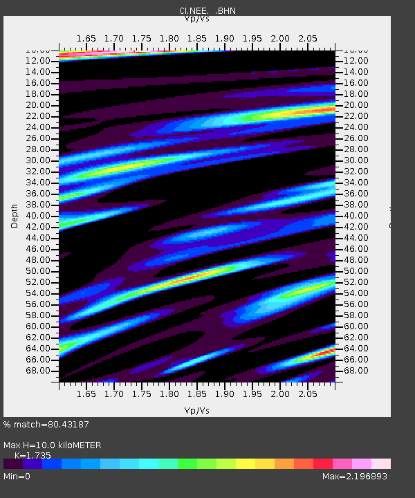
| Estimated Moho Depth: |
10.0 km |
| Estimated Crust Vp/Vs: |
1.74 |
| Assumed Crust Vp: |
6.276 km/s |
| Estimated Crust Vs: |
3.617 km/s |
| Estimated Crust Poisson's Ratio: |
0.25 |
|
| Radial Match: |
80.43187 % |
| Radial Bump: |
400 |
| Transverse Match: |
84.4428 % |
| Transverse Bump: |
400 |
| SOD ConfigId: |
3787 |
| Insert Time: |
2010-02-25 21:13:03.327 +0000 |
| GWidth: |
2.5 |
| Max Bumps: |
400 |
| Tol: |
0.001 |
|

Signal To Noise
| Channel | StoN | STA | LTA |
| CI:NEE: :BHN:19990116T10:50:24.414011Z | 1.5706813 | 5.307087E-7 | 3.3788436E-7 |
| CI:NEE: :BHE:19990116T10:50:24.414011Z | 1.5154228 | 5.973097E-7 | 3.941538E-7 |
| CI:NEE: :BHZ:19990116T10:50:24.414011Z | 3.74624 | 1.7312516E-6 | 4.6213046E-7 |
| Arrivals |
| Ps | 1.3 SECOND |
| PpPs | 4.0 SECOND |
| PsPs/PpSs | 5.3 SECOND |


