You are here: Home > Network List > CN - Canadian National Seismograph Network Stations List
> Station INK INUVIK, NT > Earthquake Result Viewer
INK INUVIK, NT - Earthquake Result Viewer
*The percent match for this event was below the threshold and hence no stack was calculated.
| Earthquake location: |
Northern Mid-Atlantic Ridge |
| Earthquake latitude/longitude: |
23.8/-45.6 |
| Earthquake time(UTC): |
2014/07/27 (208) 01:28:38 GMT |
| Earthquake Depth: |
10 km |
| Earthquake Magnitude: |
5.6 MB, 6.0 MWB, 6.6 MI |
| Earthquake Catalog/Contributor: |
NEIC PDE/NEIC COMCAT |
|
| Network: |
CN Canadian National Seismograph Network |
| Station: |
INK INUVIK, NT |
| Lat/Lon: |
68.31 N/133.53 W |
| Elevation: |
44 m |
|
| Distance: |
67.4 deg |
| Az: |
336.267 deg |
| Baz: |
82.688 deg |
| Ray Param: |
$rayparam |
*The percent match for this event was below the threshold and hence was not used in the summary stack. |
|
| Radial Match: |
64.44636 % |
| Radial Bump: |
400 |
| Transverse Match: |
53.907722 % |
| Transverse Bump: |
400 |
| SOD ConfigId: |
769524 |
| Insert Time: |
2014-08-10 02:00:11.712 +0000 |
| GWidth: |
2.5 |
| Max Bumps: |
400 |
| Tol: |
0.001 |
|
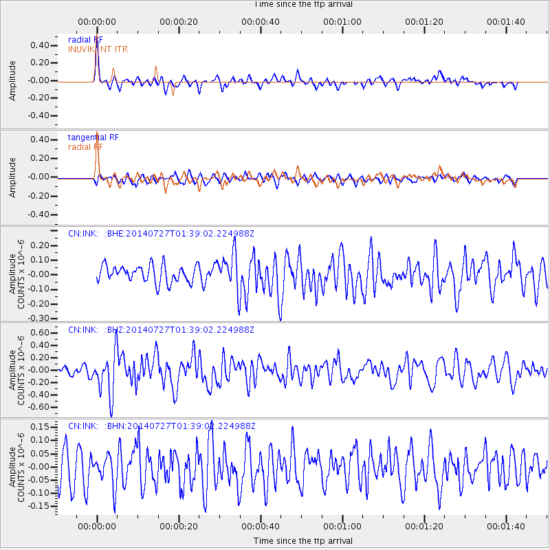
Signal To Noise
| Channel | StoN | STA | LTA |
| CN:INK: :BHZ:20140727T01:39:02.224988Z | 4.326454 | 3.4807618E-7 | 8.045299E-8 |
| CN:INK: :BHN:20140727T01:39:02.224988Z | 1.0633441 | 6.003374E-8 | 5.6457488E-8 |
| CN:INK: :BHE:20140727T01:39:02.224988Z | 2.1998034 | 1.2501312E-7 | 5.6829222E-8 |
| Arrivals |
| Ps | |
| PpPs | |
| PsPs/PpSs | |


