You are here: Home > Network List > IM - International Miscellaneous Stations Stations List
> Station NV31 NVAR Array Site 31, Mina, NV, USA > Earthquake Result Viewer
NV31 NVAR Array Site 31, Mina, NV, USA - Earthquake Result Viewer
| Earthquake location: |
Tonga Islands |
| Earthquake latitude/longitude: |
-15.2/-173.2 |
| Earthquake time(UTC): |
2015/04/07 (097) 00:46:18 GMT |
| Earthquake Depth: |
10 km |
| Earthquake Magnitude: |
5.8 MB |
| Earthquake Catalog/Contributor: |
NEIC PDE/NEIC ALERT |
|
| Network: |
IM International Miscellaneous Stations |
| Station: |
NV31 NVAR Array Site 31, Mina, NV, USA |
| Lat/Lon: |
38.43 N/118.16 W |
| Elevation: |
1509 m |
|
| Distance: |
74.2 deg |
| Az: |
42.01 deg |
| Baz: |
235.361 deg |
| Ray Param: |
0.052518994 |
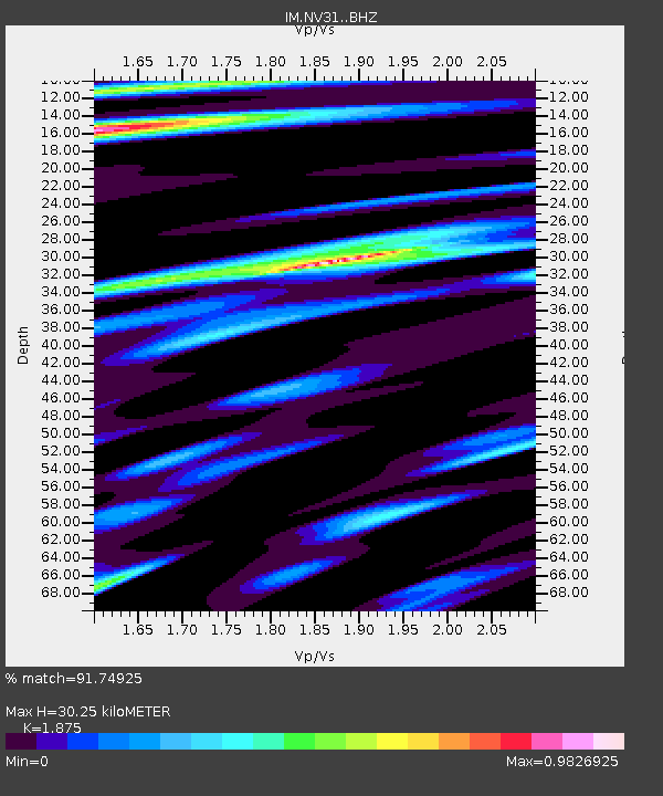
| Estimated Moho Depth: |
30.25 km |
| Estimated Crust Vp/Vs: |
1.88 |
| Assumed Crust Vp: |
6.279 km/s |
| Estimated Crust Vs: |
3.349 km/s |
| Estimated Crust Poisson's Ratio: |
0.30 |
|
| Radial Match: |
91.74925 % |
| Radial Bump: |
400 |
| Transverse Match: |
87.39462 % |
| Transverse Bump: |
400 |
| SOD ConfigId: |
7422571 |
| Insert Time: |
2019-04-18 02:58:45.600 +0000 |
| GWidth: |
2.5 |
| Max Bumps: |
400 |
| Tol: |
0.001 |
|

Signal To Noise
| Channel | StoN | STA | LTA |
| IM:NV31: :BHZ:20150407T00:57:24.599988Z | 32.0179 | 3.260211E-6 | 1.0182465E-7 |
| IM:NV31: :BHN:20150407T00:57:24.599988Z | 3.7410226 | 5.811121E-7 | 1.553351E-7 |
| IM:NV31: :BHE:20150407T00:57:24.599988Z | 7.524828 | 1.004112E-6 | 1.3343987E-7 |
| Arrivals |
| Ps | 4.3 SECOND |
| PpPs | 13 SECOND |
| PsPs/PpSs | 18 SECOND |


