You are here: Home > Network List > GB - Great Britain Seismograph Network Stations List
> Station CWF CHARNWOOD FOREST, ENGLAND > Earthquake Result Viewer
CWF CHARNWOOD FOREST, ENGLAND - Earthquake Result Viewer
| Earthquake location: |
Northern Mid-Atlantic Ridge |
| Earthquake latitude/longitude: |
23.8/-45.6 |
| Earthquake time(UTC): |
2014/07/27 (208) 01:28:38 GMT |
| Earthquake Depth: |
10 km |
| Earthquake Magnitude: |
5.6 MB, 6.0 MWB, 6.6 MI |
| Earthquake Catalog/Contributor: |
NEIC PDE/NEIC COMCAT |
|
| Network: |
GB Great Britain Seismograph Network |
| Station: |
CWF CHARNWOOD FOREST, ENGLAND |
| Lat/Lon: |
52.74 N/1.31 W |
| Elevation: |
203 m |
|
| Distance: |
44.2 deg |
| Az: |
37.532 deg |
| Baz: |
246.634 deg |
| Ray Param: |
0.07204419 |
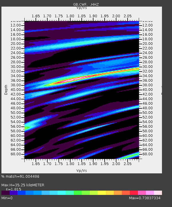
| Estimated Moho Depth: |
35.25 km |
| Estimated Crust Vp/Vs: |
1.82 |
| Assumed Crust Vp: |
6.276 km/s |
| Estimated Crust Vs: |
3.458 km/s |
| Estimated Crust Poisson's Ratio: |
0.28 |
|
| Radial Match: |
91.004486 % |
| Radial Bump: |
328 |
| Transverse Match: |
78.59047 % |
| Transverse Bump: |
400 |
| SOD ConfigId: |
769524 |
| Insert Time: |
2014-08-10 02:04:18.761 +0000 |
| GWidth: |
2.5 |
| Max Bumps: |
400 |
| Tol: |
0.001 |
|

Signal To Noise
| Channel | StoN | STA | LTA |
| GB:CWF: :HHZ:20140727T01:36:16.478986Z | 8.731782 | 5.953599E-7 | 6.818309E-8 |
| GB:CWF: :HHN:20140727T01:36:16.478986Z | 3.0022688 | 1.2895009E-7 | 4.295088E-8 |
| GB:CWF: :HHE:20140727T01:36:16.478986Z | 6.144274 | 3.1808818E-7 | 5.1769852E-8 |
| Arrivals |
| Ps | 4.9 SECOND |
| PpPs | 15 SECOND |
| PsPs/PpSs | 20 SECOND |


