You are here: Home > Network List > GS - US Geological Survey Networks Stations List
> Station OK027 Henny and Sorgum Hills Rd. > Earthquake Result Viewer
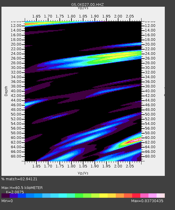
OK027 Henny and Sorgum Hills Rd. - Earthquake Result Viewer
| Earthquake location: |
Northern Mid-Atlantic Ridge |
| Earthquake latitude/longitude: |
23.8/-45.6 |
| Earthquake time(UTC): |
2014/07/27 (208) 01:28:38 GMT |
| Earthquake Depth: |
10 km |
| Earthquake Magnitude: |
5.6 MB, 6.0 MWB, 6.6 MI |
| Earthquake Catalog/Contributor: |
NEIC PDE/NEIC COMCAT |
|
| Network: |
GS US Geological Survey Networks |
| Station: |
OK027 Henny and Sorgum Hills Rd. |
| Lat/Lon: |
35.71 N/97.28 W |
| Elevation: |
364 m |
|
| Distance: |
45.9 deg |
| Az: |
297.351 deg |
| Baz: |
90.35 deg |
| Ray Param: |
0.07096219 |
| Estimated Moho Depth: |
60.5 km |
| Estimated Crust Vp/Vs: |
2.09 |
| Assumed Crust Vp: |
6.426 km/s |
| Estimated Crust Vs: |
3.078 km/s |
| Estimated Crust Poisson's Ratio: |
0.35 |
|
| Radial Match: |
82.94121 % |
| Radial Bump: |
400 |
| Transverse Match: |
76.53105 % |
| Transverse Bump: |
400 |
| SOD ConfigId: |
769524 |
| Insert Time: |
2014-08-10 02:07:39.190 +0000 |
| GWidth: |
2.5 |
| Max Bumps: |
400 |
| Tol: |
0.001 |
|

Signal To Noise
| Channel | StoN | STA | LTA |
| GS:OK027:00:HHZ:20140727T01:36:29.918988Z | 5.457159 | 3.2636717E-7 | 5.980532E-8 |
| GS:OK027:00:HH1:20140727T01:36:29.918988Z | 1.3701634 | 1.3082624E-7 | 9.548221E-8 |
| GS:OK027:00:HH2:20140727T01:36:29.918988Z | 3.950469 | 3.8313829E-7 | 9.698552E-8 |
| Arrivals |
| Ps | 11 SECOND |
| PpPs | 28 SECOND |
| PsPs/PpSs | 38 SECOND |


