You are here: Home > Network List > N4 - Central and EAstern US Network Stations List
> Station N41A Harden Midland Farm, Stronghurst, IL, USA > Earthquake Result Viewer
N41A Harden Midland Farm, Stronghurst, IL, USA - Earthquake Result Viewer
| Earthquake location: |
Tonga Islands |
| Earthquake latitude/longitude: |
-15.2/-173.2 |
| Earthquake time(UTC): |
2015/04/07 (097) 00:46:18 GMT |
| Earthquake Depth: |
10 km |
| Earthquake Magnitude: |
5.8 MB |
| Earthquake Catalog/Contributor: |
NEIC PDE/NEIC ALERT |
|
| Network: |
N4 Central and EAstern US Network |
| Station: |
N41A Harden Midland Farm, Stronghurst, IL, USA |
| Lat/Lon: |
40.71 N/90.86 W |
| Elevation: |
226 m |
|
| Distance: |
94.1 deg |
| Az: |
49.062 deg |
| Baz: |
253.615 deg |
| Ray Param: |
0.041119028 |
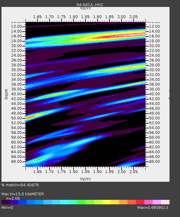
| Estimated Moho Depth: |
15.0 km |
| Estimated Crust Vp/Vs: |
2.08 |
| Assumed Crust Vp: |
6.498 km/s |
| Estimated Crust Vs: |
3.124 km/s |
| Estimated Crust Poisson's Ratio: |
0.35 |
|
| Radial Match: |
84.40679 % |
| Radial Bump: |
218 |
| Transverse Match: |
70.28046 % |
| Transverse Bump: |
289 |
| SOD ConfigId: |
7422571 |
| Insert Time: |
2019-04-18 02:59:28.531 +0000 |
| GWidth: |
2.5 |
| Max Bumps: |
400 |
| Tol: |
0.001 |
|

Signal To Noise
| Channel | StoN | STA | LTA |
| N4:N41A: :HHZ:20150407T00:59:05.959973Z | 17.359404 | 2.2870654E-6 | 1.3174794E-7 |
| N4:N41A: :HHN:20150407T00:59:05.959973Z | 1.235318 | 2.3052093E-7 | 1.8660857E-7 |
| N4:N41A: :HHE:20150407T00:59:05.959973Z | 4.314563 | 8.209636E-7 | 1.9027735E-7 |
| Arrivals |
| Ps | 2.5 SECOND |
| PpPs | 7.0 SECOND |
| PsPs/PpSs | 9.5 SECOND |


