You are here: Home > Network List > NN - Western Great Basin/Eastern Sierra Nevada Stations List
> Station RYN Ryan, Nevada w84,gps > Earthquake Result Viewer
RYN Ryan, Nevada w84,gps - Earthquake Result Viewer
| Earthquake location: |
Tonga Islands |
| Earthquake latitude/longitude: |
-15.2/-173.2 |
| Earthquake time(UTC): |
2015/04/07 (097) 00:46:18 GMT |
| Earthquake Depth: |
10 km |
| Earthquake Magnitude: |
5.8 MB |
| Earthquake Catalog/Contributor: |
NEIC PDE/NEIC ALERT |
|
| Network: |
NN Western Great Basin/Eastern Sierra Nevada |
| Station: |
RYN Ryan, Nevada w84,gps |
| Lat/Lon: |
38.63 N/118.52 W |
| Elevation: |
1651 m |
|
| Distance: |
74.0 deg |
| Az: |
41.673 deg |
| Baz: |
235.041 deg |
| Ray Param: |
0.05260304 |
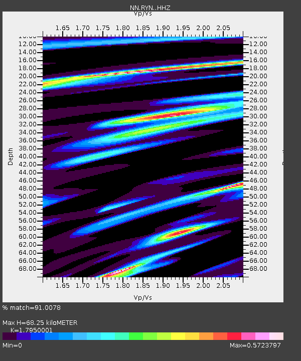
| Estimated Moho Depth: |
68.25 km |
| Estimated Crust Vp/Vs: |
1.80 |
| Assumed Crust Vp: |
6.279 km/s |
| Estimated Crust Vs: |
3.498 km/s |
| Estimated Crust Poisson's Ratio: |
0.27 |
|
| Radial Match: |
91.0078 % |
| Radial Bump: |
236 |
| Transverse Match: |
87.049 % |
| Transverse Bump: |
303 |
| SOD ConfigId: |
7422571 |
| Insert Time: |
2019-04-18 03:00:18.111 +0000 |
| GWidth: |
2.5 |
| Max Bumps: |
400 |
| Tol: |
0.001 |
|

Signal To Noise
| Channel | StoN | STA | LTA |
| NN:RYN: :HHZ:20150407T00:57:23.875012Z | 25.08624 | 2.7762328E-6 | 1.1066755E-7 |
| NN:RYN: :HHN:20150407T00:57:23.875012Z | 6.2562313 | 6.806951E-7 | 1.0880274E-7 |
| NN:RYN: :HHE:20150407T00:57:23.875012Z | 4.331554 | 7.1770876E-7 | 1.6569315E-7 |
| Arrivals |
| Ps | 8.9 SECOND |
| PpPs | 29 SECOND |
| PsPs/PpSs | 38 SECOND |


