You are here: Home > Network List > II - Global Seismograph Network (GSN - IRIS/IDA) Stations List
> Station NIL Nilore, Pakistan > Earthquake Result Viewer
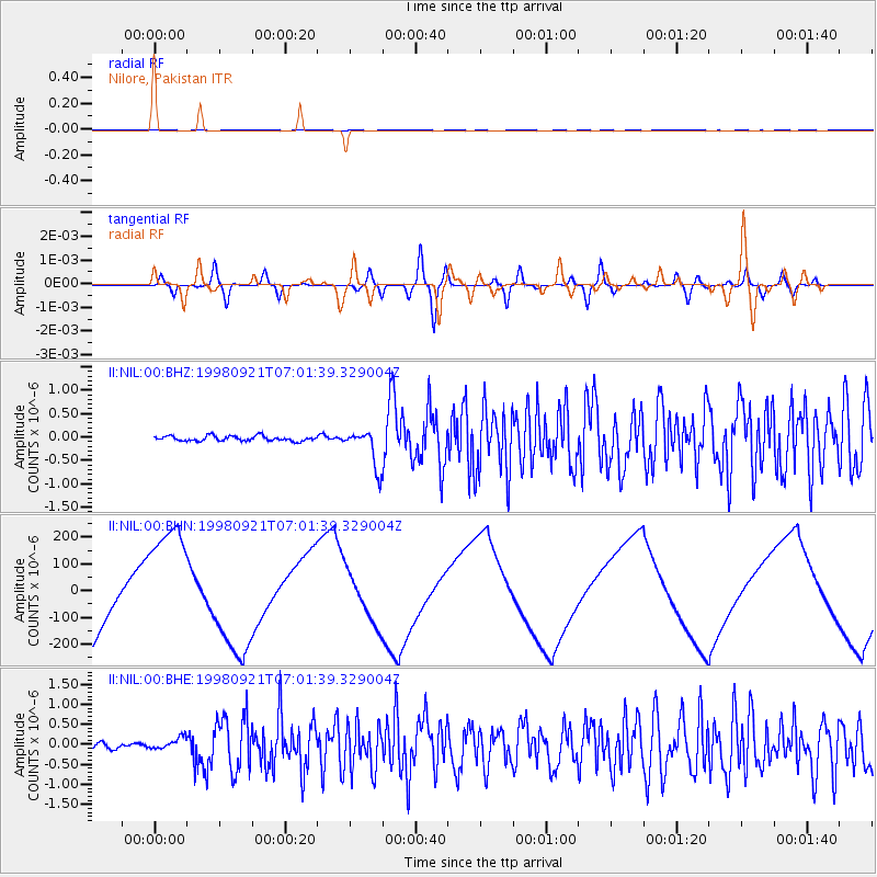
NIL Nilore, Pakistan - Earthquake Result Viewer
*The percent match for this event was below the threshold and hence no stack was calculated.
| Earthquake location: |
Minahassa Peninsula, Sulawesi |
| Earthquake latitude/longitude: |
0.3/122.5 |
| Earthquake time(UTC): |
1998/09/21 (264) 06:52:41 GMT |
| Earthquake Depth: |
147 km |
| Earthquake Magnitude: |
6.1 MB, 6.0 UNKNOWN, 5.9 MW |
| Earthquake Catalog/Contributor: |
WHDF/NEIC |
|
| Network: |
II Global Seismograph Network (GSN - IRIS/IDA) |
| Station: |
NIL Nilore, Pakistan |
| Lat/Lon: |
33.65 N/73.27 E |
| Elevation: |
629 m |
|
| Distance: |
56.8 deg |
| Az: |
311.009 deg |
| Baz: |
115.225 deg |
| Ray Param: |
$rayparam |
*The percent match for this event was below the threshold and hence was not used in the summary stack. |
|
| Radial Match: |
15.695634 % |
| Radial Bump: |
400 |
| Transverse Match: |
13.977623 % |
| Transverse Bump: |
400 |
| SOD ConfigId: |
4480 |
| Insert Time: |
2010-03-02 00:29:36.851 +0000 |
| GWidth: |
2.5 |
| Max Bumps: |
400 |
| Tol: |
0.001 |
|
Signal To Noise
| Channel | StoN | STA | LTA |
| II:NIL:00:BHN:19980921T07:01:39.329004Z | 1.5859555 | 2.1632224E-4 | 1.3639868E-4 |
| II:NIL:00:BHE:19980921T07:01:39.329004Z | 1.8953438 | 1.5338078E-7 | 8.092504E-8 |
| II:NIL:00:BHZ:19980921T07:01:39.329004Z | 7.446604 | 4.0219334E-7 | 5.4010304E-8 |
| Arrivals |
| Ps | |
| PpPs | |
| PsPs/PpSs | |


