You are here: Home > Network List > N4 - Central and EAstern US Network Stations List
> Station K43A Burlington, WI, USA > Earthquake Result Viewer
K43A Burlington, WI, USA - Earthquake Result Viewer
| Earthquake location: |
Northern Mid-Atlantic Ridge |
| Earthquake latitude/longitude: |
23.8/-45.6 |
| Earthquake time(UTC): |
2014/07/27 (208) 01:28:38 GMT |
| Earthquake Depth: |
10 km |
| Earthquake Magnitude: |
5.6 MB, 6.0 MWB, 6.6 MI |
| Earthquake Catalog/Contributor: |
NEIC PDE/NEIC COMCAT |
|
| Network: |
N4 Central and EAstern US Network |
| Station: |
K43A Burlington, WI, USA |
| Lat/Lon: |
42.70 N/88.33 W |
| Elevation: |
264 m |
|
| Distance: |
39.9 deg |
| Az: |
308.816 deg |
| Baz: |
104.425 deg |
| Ray Param: |
0.07471412 |
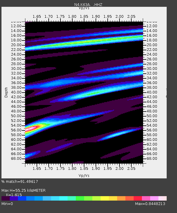
| Estimated Moho Depth: |
55.25 km |
| Estimated Crust Vp/Vs: |
1.62 |
| Assumed Crust Vp: |
6.571 km/s |
| Estimated Crust Vs: |
4.069 km/s |
| Estimated Crust Poisson's Ratio: |
0.19 |
|
| Radial Match: |
91.49617 % |
| Radial Bump: |
237 |
| Transverse Match: |
75.33884 % |
| Transverse Bump: |
400 |
| SOD ConfigId: |
769524 |
| Insert Time: |
2014-08-10 02:18:05.639 +0000 |
| GWidth: |
2.5 |
| Max Bumps: |
400 |
| Tol: |
0.001 |
|

Signal To Noise
| Channel | StoN | STA | LTA |
| N4:K43A: :HHZ:20140727T01:35:41.150006Z | 3.4570546 | 4.2666608E-7 | 1.2341896E-7 |
| N4:K43A: :HHN:20140727T01:35:41.150006Z | 1.3229921 | 1.1694521E-7 | 8.839449E-8 |
| N4:K43A: :HHE:20140727T01:35:41.150006Z | 3.4913852 | 2.7748885E-7 | 7.947815E-8 |
| Arrivals |
| Ps | 5.6 SECOND |
| PpPs | 20 SECOND |
| PsPs/PpSs | 26 SECOND |


