You are here: Home > Network List > CI - Caltech Regional Seismic Network Stations List
> Station NEE Needles, California, USA > Earthquake Result Viewer
NEE Needles, California, USA - Earthquake Result Viewer
| Earthquake location: |
Southern Peru |
| Earthquake latitude/longitude: |
-16.1/-71.4 |
| Earthquake time(UTC): |
1998/10/08 (281) 04:51:42 GMT |
| Earthquake Depth: |
136 km |
| Earthquake Magnitude: |
6.1 MB, 6.4 UNKNOWN, 6.2 MW |
| Earthquake Catalog/Contributor: |
WHDF/NEIC |
|
| Network: |
CI Caltech Regional Seismic Network |
| Station: |
NEE Needles, California, USA |
| Lat/Lon: |
34.82 N/114.60 W |
| Elevation: |
139 m |
|
| Distance: |
65.2 deg |
| Az: |
321.655 deg |
| Baz: |
133.546 deg |
| Ray Param: |
0.058052562 |
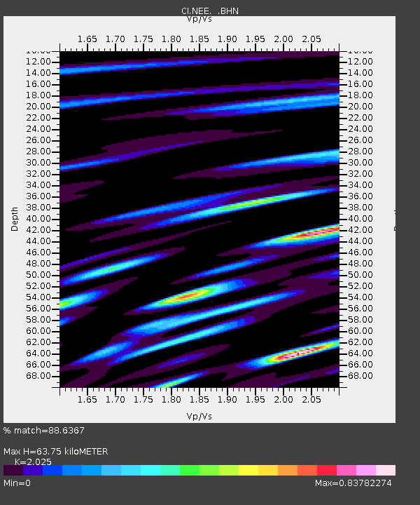
| Estimated Moho Depth: |
63.75 km |
| Estimated Crust Vp/Vs: |
2.03 |
| Assumed Crust Vp: |
6.276 km/s |
| Estimated Crust Vs: |
3.099 km/s |
| Estimated Crust Poisson's Ratio: |
0.34 |
|
| Radial Match: |
88.6367 % |
| Radial Bump: |
334 |
| Transverse Match: |
70.18201 % |
| Transverse Bump: |
400 |
| SOD ConfigId: |
4480 |
| Insert Time: |
2010-02-25 21:13:06.980 +0000 |
| GWidth: |
2.5 |
| Max Bumps: |
400 |
| Tol: |
0.001 |
|

Signal To Noise
| Channel | StoN | STA | LTA |
| CI:NEE: :BHN:19981008T05:01:38.680005Z | 5.2606153 | 1.7173779E-6 | 3.2645949E-7 |
| CI:NEE: :BHE:19981008T05:01:38.680005Z | 3.5098536 | 1.0932924E-6 | 3.114923E-7 |
| CI:NEE: :BHZ:19981008T05:01:38.680005Z | 2.300436 | 9.215859E-7 | 4.0061357E-7 |
| Arrivals |
| Ps | 11 SECOND |
| PpPs | 30 SECOND |
| PsPs/PpSs | 40 SECOND |


