You are here: Home > Network List > II - Global Seismograph Network (GSN - IRIS/IDA) Stations List
> Station NIL Nilore, Pakistan > Earthquake Result Viewer
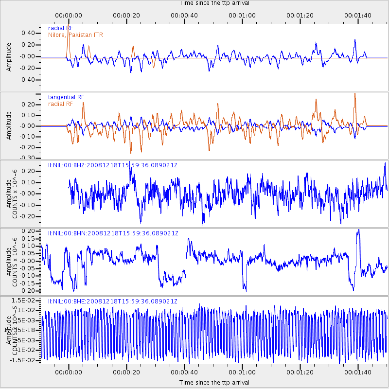
NIL Nilore, Pakistan - Earthquake Result Viewer
*The percent match for this event was below the threshold and hence no stack was calculated.
| Earthquake location: |
Northern Molucca Sea |
| Earthquake latitude/longitude: |
2.3/127.2 |
| Earthquake time(UTC): |
2008/12/18 (353) 15:50:15 GMT |
| Earthquake Depth: |
87 km |
| Earthquake Magnitude: |
5.6 MB, 5.3 MW, 5.2 MW |
| Earthquake Catalog/Contributor: |
WHDF/NEIC |
|
| Network: |
II Global Seismograph Network (GSN - IRIS/IDA) |
| Station: |
NIL Nilore, Pakistan |
| Lat/Lon: |
33.65 N/73.27 E |
| Elevation: |
629 m |
|
| Distance: |
59.1 deg |
| Az: |
308.261 deg |
| Baz: |
109.851 deg |
| Ray Param: |
$rayparam |
*The percent match for this event was below the threshold and hence was not used in the summary stack. |
|
| Radial Match: |
49.040943 % |
| Radial Bump: |
400 |
| Transverse Match: |
48.90057 % |
| Transverse Bump: |
400 |
| SOD ConfigId: |
2658 |
| Insert Time: |
2010-03-02 00:29:46.757 +0000 |
| GWidth: |
2.5 |
| Max Bumps: |
400 |
| Tol: |
0.001 |
|
Signal To Noise
| Channel | StoN | STA | LTA |
| II:NIL:00:BHN:20081218T15:59:36.089021Z | 2.1690323 | 1.0837981E-7 | 4.9966893E-8 |
| II:NIL:00:BHE:20081218T15:59:36.089021Z | 1.0426099 | 9.7527355E-9 | 9.354155E-9 |
| II:NIL:00:BHZ:20081218T15:59:36.089021Z | 0.7597934 | 6.4966464E-8 | 8.550543E-8 |
| Arrivals |
| Ps | |
| PpPs | |
| PsPs/PpSs | |


