You are here: Home > Network List > N4 - Central and EAstern US Network Stations List
> Station T35B Sooner Cattle Company, Foraker, OK, USA > Earthquake Result Viewer
T35B Sooner Cattle Company, Foraker, OK, USA - Earthquake Result Viewer
| Earthquake location: |
Northern Mid-Atlantic Ridge |
| Earthquake latitude/longitude: |
23.8/-45.6 |
| Earthquake time(UTC): |
2014/07/27 (208) 01:28:38 GMT |
| Earthquake Depth: |
10 km |
| Earthquake Magnitude: |
5.6 MB, 6.0 MWB, 6.6 MI |
| Earthquake Catalog/Contributor: |
NEIC PDE/NEIC COMCAT |
|
| Network: |
N4 Central and EAstern US Network |
| Station: |
T35B Sooner Cattle Company, Foraker, OK, USA |
| Lat/Lon: |
36.92 N/96.51 W |
| Elevation: |
413 m |
|
| Distance: |
45.3 deg |
| Az: |
299.05 deg |
| Baz: |
91.993 deg |
| Ray Param: |
0.07135191 |
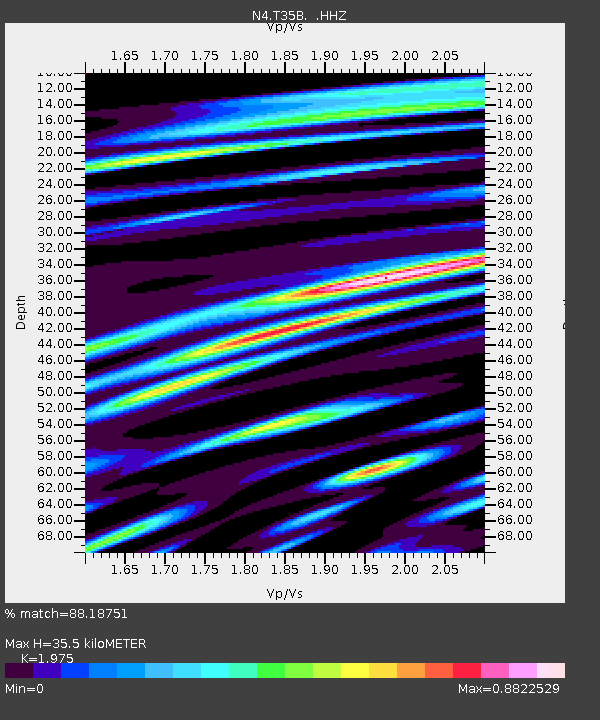
| Estimated Moho Depth: |
35.5 km |
| Estimated Crust Vp/Vs: |
1.98 |
| Assumed Crust Vp: |
6.483 km/s |
| Estimated Crust Vs: |
3.282 km/s |
| Estimated Crust Poisson's Ratio: |
0.33 |
|
| Radial Match: |
88.18751 % |
| Radial Bump: |
400 |
| Transverse Match: |
53.90862 % |
| Transverse Bump: |
400 |
| SOD ConfigId: |
769524 |
| Insert Time: |
2014-08-10 02:19:20.797 +0000 |
| GWidth: |
2.5 |
| Max Bumps: |
400 |
| Tol: |
0.001 |
|

Signal To Noise
| Channel | StoN | STA | LTA |
| N4:T35B: :HHZ:20140727T01:36:25.190015Z | 4.737317 | 2.9847143E-7 | 6.300432E-8 |
| N4:T35B: :HHN:20140727T01:36:25.190015Z | 0.6587473 | 3.8706695E-8 | 5.875803E-8 |
| N4:T35B: :HHE:20140727T01:36:25.190015Z | 5.1776075 | 1.6278241E-7 | 3.1439697E-8 |
| Arrivals |
| Ps | 5.7 SECOND |
| PpPs | 15 SECOND |
| PsPs/PpSs | 21 SECOND |


