You are here: Home > Network List > N4 - Central and EAstern US Network Stations List
> Station Y45B Coffeeville, MS, USA > Earthquake Result Viewer
Y45B Coffeeville, MS, USA - Earthquake Result Viewer
| Earthquake location: |
Northern Mid-Atlantic Ridge |
| Earthquake latitude/longitude: |
23.8/-45.6 |
| Earthquake time(UTC): |
2014/07/27 (208) 01:28:38 GMT |
| Earthquake Depth: |
10 km |
| Earthquake Magnitude: |
5.6 MB, 6.0 MWB, 6.6 MI |
| Earthquake Catalog/Contributor: |
NEIC PDE/NEIC COMCAT |
|
| Network: |
N4 Central and EAstern US Network |
| Station: |
Y45B Coffeeville, MS, USA |
| Lat/Lon: |
33.87 N/89.54 W |
| Elevation: |
101 m |
|
| Distance: |
39.5 deg |
| Az: |
294.914 deg |
| Baz: |
92.958 deg |
| Ray Param: |
0.07494631 |
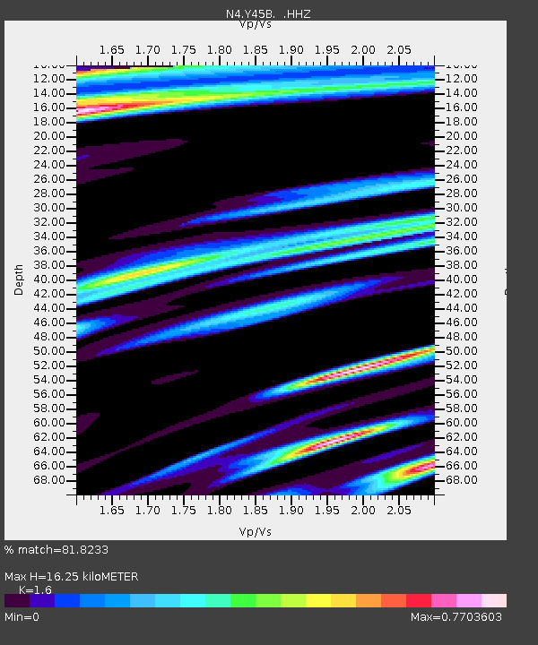
| Estimated Moho Depth: |
16.25 km |
| Estimated Crust Vp/Vs: |
1.60 |
| Assumed Crust Vp: |
6.201 km/s |
| Estimated Crust Vs: |
3.876 km/s |
| Estimated Crust Poisson's Ratio: |
0.18 |
|
| Radial Match: |
81.8233 % |
| Radial Bump: |
400 |
| Transverse Match: |
74.76448 % |
| Transverse Bump: |
400 |
| SOD ConfigId: |
769524 |
| Insert Time: |
2014-08-10 02:20:25.287 +0000 |
| GWidth: |
2.5 |
| Max Bumps: |
400 |
| Tol: |
0.001 |
|

Signal To Noise
| Channel | StoN | STA | LTA |
| N4:Y45B: :HHZ:20140727T01:35:37.889996Z | 3.3483725 | 2.9880184E-7 | 8.923793E-8 |
| N4:Y45B: :HHN:20140727T01:35:37.889996Z | 1.3276182 | 1.9253258E-7 | 1.4502105E-7 |
| N4:Y45B: :HHE:20140727T01:35:37.889996Z | 1.3275946 | 2.458534E-7 | 1.851871E-7 |
| Arrivals |
| Ps | 1.7 SECOND |
| PpPs | 6.3 SECOND |
| PsPs/PpSs | 8.0 SECOND |


