You are here: Home > Network List > N4 - Central and EAstern US Network Stations List
> Station Q51A Peebles, OH, USA > Earthquake Result Viewer
Q51A Peebles, OH, USA - Earthquake Result Viewer
| Earthquake location: |
Northern Mid-Atlantic Ridge |
| Earthquake latitude/longitude: |
23.8/-45.6 |
| Earthquake time(UTC): |
2014/07/27 (208) 01:28:38 GMT |
| Earthquake Depth: |
10 km |
| Earthquake Magnitude: |
5.6 MB, 6.0 MWB, 6.6 MI |
| Earthquake Catalog/Contributor: |
NEIC PDE/NEIC COMCAT |
|
| Network: |
N4 Central and EAstern US Network |
| Station: |
Q51A Peebles, OH, USA |
| Lat/Lon: |
39.03 N/83.35 W |
| Elevation: |
362 m |
|
| Distance: |
35.3 deg |
| Az: |
304.523 deg |
| Baz: |
104.274 deg |
| Ray Param: |
0.07728572 |
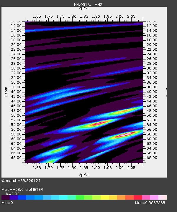
| Estimated Moho Depth: |
58.0 km |
| Estimated Crust Vp/Vs: |
2.02 |
| Assumed Crust Vp: |
6.232 km/s |
| Estimated Crust Vs: |
3.085 km/s |
| Estimated Crust Poisson's Ratio: |
0.34 |
|
| Radial Match: |
89.329124 % |
| Radial Bump: |
222 |
| Transverse Match: |
89.67946 % |
| Transverse Bump: |
227 |
| SOD ConfigId: |
769524 |
| Insert Time: |
2014-08-10 02:21:54.186 +0000 |
| GWidth: |
2.5 |
| Max Bumps: |
400 |
| Tol: |
0.001 |
|

Signal To Noise
| Channel | StoN | STA | LTA |
| N4:Q51A: :HHZ:20140727T01:35:02.490002Z | 6.2823057 | 3.7608743E-7 | 5.9864554E-8 |
| N4:Q51A: :HHN:20140727T01:35:02.490002Z | 0.9087836 | 2.9772367E-9 | 3.2760679E-9 |
| N4:Q51A: :HHE:20140727T01:35:02.490002Z | 4.0124693 | 2.4868245E-7 | 6.197741E-8 |
| Arrivals |
| Ps | 10 SECOND |
| PpPs | 26 SECOND |
| PsPs/PpSs | 37 SECOND |


