You are here: Home > Network List > OK - Oklahoma Seismic Network Stations List
> Station BCOK Bluff Creek, North Oklahoma City, Oklahoma > Earthquake Result Viewer
BCOK Bluff Creek, North Oklahoma City, Oklahoma - Earthquake Result Viewer
| Earthquake location: |
Northern Mid-Atlantic Ridge |
| Earthquake latitude/longitude: |
23.8/-45.6 |
| Earthquake time(UTC): |
2014/07/27 (208) 01:28:38 GMT |
| Earthquake Depth: |
10 km |
| Earthquake Magnitude: |
5.6 MB, 6.0 MWB, 6.6 MI |
| Earthquake Catalog/Contributor: |
NEIC PDE/NEIC COMCAT |
|
| Network: |
OK Oklahoma Seismic Network |
| Station: |
BCOK Bluff Creek, North Oklahoma City, Oklahoma |
| Lat/Lon: |
35.66 N/97.61 W |
| Elevation: |
302 m |
|
| Distance: |
46.2 deg |
| Az: |
297.273 deg |
| Baz: |
90.107 deg |
| Ray Param: |
0.07079805 |
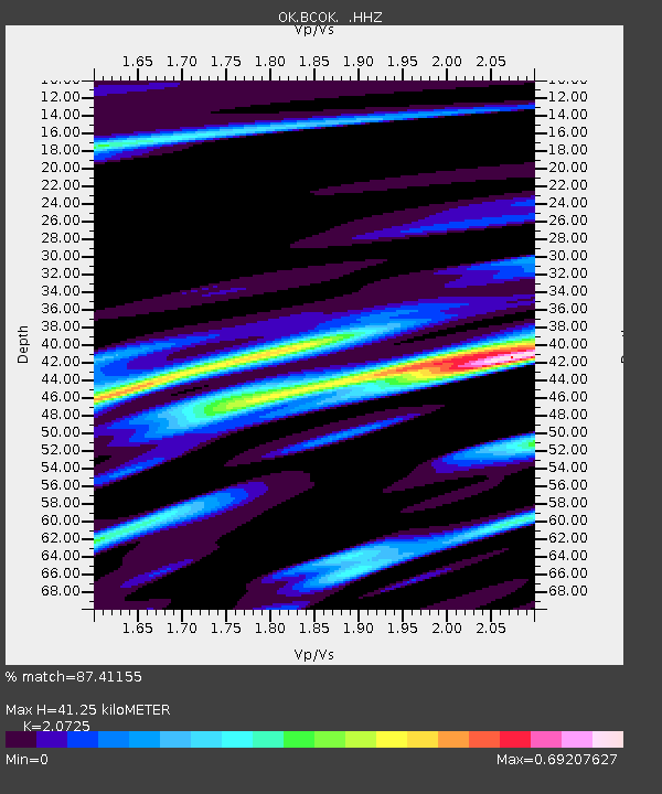
| Estimated Moho Depth: |
41.25 km |
| Estimated Crust Vp/Vs: |
2.07 |
| Assumed Crust Vp: |
6.426 km/s |
| Estimated Crust Vs: |
3.101 km/s |
| Estimated Crust Poisson's Ratio: |
0.35 |
|
| Radial Match: |
87.41155 % |
| Radial Bump: |
400 |
| Transverse Match: |
64.226234 % |
| Transverse Bump: |
400 |
| SOD ConfigId: |
769524 |
| Insert Time: |
2014-08-10 02:26:25.337 +0000 |
| GWidth: |
2.5 |
| Max Bumps: |
400 |
| Tol: |
0.001 |
|

Signal To Noise
| Channel | StoN | STA | LTA |
| OK:BCOK: :HHZ:20140727T01:36:32.009015Z | 4.5900292 | 1.0403458E-6 | 2.2665338E-7 |
| OK:BCOK: :HHN:20140727T01:36:32.009015Z | 0.9341651 | 3.3376782E-7 | 3.5728996E-7 |
| OK:BCOK: :HHE:20140727T01:36:32.009015Z | 3.541708 | 8.236038E-7 | 2.3254422E-7 |
| Arrivals |
| Ps | 7.3 SECOND |
| PpPs | 19 SECOND |
| PsPs/PpSs | 26 SECOND |


