You are here: Home > Network List > PE - Penn State Network Stations List
> Station PAGS PA Geological Survey > Earthquake Result Viewer
PAGS PA Geological Survey - Earthquake Result Viewer
| Earthquake location: |
Northern Mid-Atlantic Ridge |
| Earthquake latitude/longitude: |
23.8/-45.6 |
| Earthquake time(UTC): |
2014/07/27 (208) 01:28:38 GMT |
| Earthquake Depth: |
10 km |
| Earthquake Magnitude: |
5.6 MB, 6.0 MWB, 6.6 MI |
| Earthquake Catalog/Contributor: |
NEIC PDE/NEIC COMCAT |
|
| Network: |
PE Penn State Network |
| Station: |
PAGS PA Geological Survey |
| Lat/Lon: |
40.23 N/76.72 W |
| Elevation: |
120 m |
|
| Distance: |
30.8 deg |
| Az: |
309.578 deg |
| Baz: |
112.724 deg |
| Ray Param: |
0.07922484 |
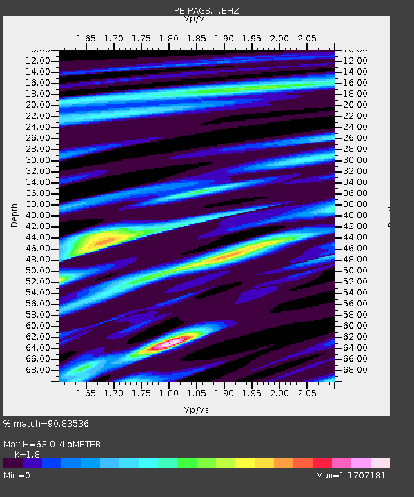
| Estimated Moho Depth: |
63.0 km |
| Estimated Crust Vp/Vs: |
1.80 |
| Assumed Crust Vp: |
6.121 km/s |
| Estimated Crust Vs: |
3.4 km/s |
| Estimated Crust Poisson's Ratio: |
0.28 |
|
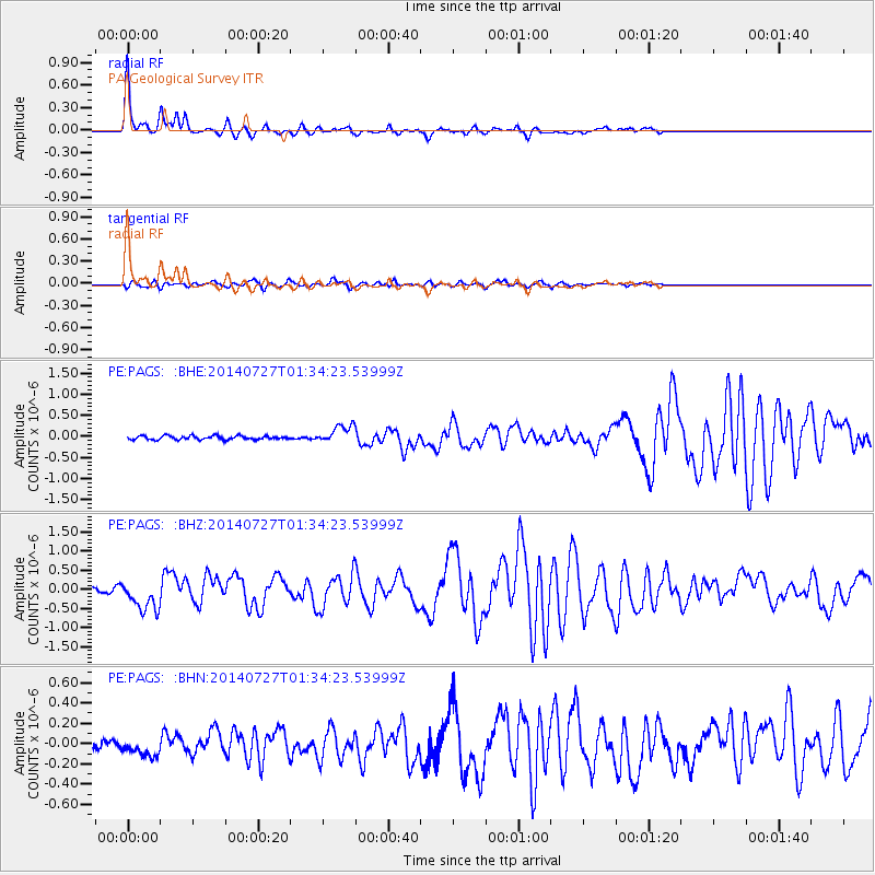
| Radial Match: |
90.83536 % |
| Radial Bump: |
243 |
| Transverse Match: |
70.89043 % |
| Transverse Bump: |
390 |
| SOD ConfigId: |
769524 |
| Insert Time: |
2014-08-10 02:27:11.065 +0000 |
| GWidth: |
2.5 |
| Max Bumps: |
400 |
| Tol: |
0.001 |
|
Signal To Noise
| Channel | StoN | STA | LTA |
| PE:PAGS: :BHZ:20140727T01:34:23.53999Z | 5.3332653 | 3.9487287E-7 | 7.4039605E-8 |
| PE:PAGS: :BHN:20140727T01:34:23.53999Z | 1.8992208 | 8.914841E-8 | 4.6939466E-8 |
| PE:PAGS: :BHE:20140727T01:34:23.53999Z | 4.7903275 | 2.1303671E-7 | 4.4472262E-8 |
| Arrivals |
| Ps | 8.8 SECOND |
| PpPs | 27 SECOND |
| PsPs/PpSs | 36 SECOND |


