You are here: Home > Network List > PE - Penn State Network Stations List
> Station WRPS We R Penn State > Earthquake Result Viewer
WRPS We R Penn State - Earthquake Result Viewer

| Earthquake location: |
Northern Mid-Atlantic Ridge |
| Earthquake latitude/longitude: |
23.8/-45.6 |
| Earthquake time(UTC): |
2014/07/27 (208) 01:28:38 GMT |
| Earthquake Depth: |
10 km |
| Earthquake Magnitude: |
5.6 MB, 6.0 MWB, 6.6 MI |
| Earthquake Catalog/Contributor: |
NEIC PDE/NEIC COMCAT |
|
| Network: |
PE Penn State Network |
| Station: |
WRPS We R Penn State |
| Lat/Lon: |
40.79 N/77.87 W |
| Elevation: |
320 m |
|
| Distance: |
31.9 deg |
| Az: |
309.941 deg |
| Baz: |
112.294 deg |
| Ray Param: |
0.07889416 |
| Estimated Moho Depth: |
58.75 km |
| Estimated Crust Vp/Vs: |
1.63 |
| Assumed Crust Vp: |
6.121 km/s |
| Estimated Crust Vs: |
3.749 km/s |
| Estimated Crust Poisson's Ratio: |
0.20 |
|
| Radial Match: |
89.23186 % |
| Radial Bump: |
263 |
| Transverse Match: |
75.047066 % |
| Transverse Bump: |
385 |
| SOD ConfigId: |
769524 |
| Insert Time: |
2014-08-10 02:27:28.849 +0000 |
| GWidth: |
2.5 |
| Max Bumps: |
400 |
| Tol: |
0.001 |
|
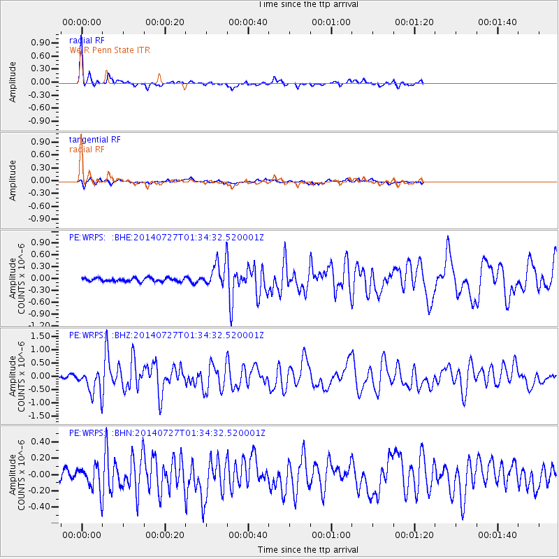
Signal To Noise
| Channel | StoN | STA | LTA |
| PE:WRPS: :BHZ:20140727T01:34:32.520001Z | 6.3397565 | 4.7450135E-7 | 7.484536E-8 |
| PE:WRPS: :BHN:20140727T01:34:32.520001Z | 2.5629468 | 1.4742307E-7 | 5.752092E-8 |
| PE:WRPS: :BHE:20140727T01:34:32.520001Z | 7.2506757 | 3.2313918E-7 | 4.4566768E-8 |
| Arrivals |
| Ps | 6.6 SECOND |
| PpPs | 23 SECOND |
| PsPs/PpSs | 30 SECOND |


