You are here: Home > Network List > TA - USArray Transportable Network (new EarthScope stations) Stations List
> Station D50A G1974 Best Township, ON, CAN > Earthquake Result Viewer
D50A G1974 Best Township, ON, CAN - Earthquake Result Viewer
| Earthquake location: |
Northern Mid-Atlantic Ridge |
| Earthquake latitude/longitude: |
23.8/-45.6 |
| Earthquake time(UTC): |
2014/07/27 (208) 01:28:38 GMT |
| Earthquake Depth: |
10 km |
| Earthquake Magnitude: |
5.6 MB, 6.0 MWB, 6.6 MI |
| Earthquake Catalog/Contributor: |
NEIC PDE/NEIC COMCAT |
|
| Network: |
TA USArray Transportable Network (new EarthScope stations) |
| Station: |
D50A G1974 Best Township, ON, CAN |
| Lat/Lon: |
47.17 N/79.84 W |
| Elevation: |
331 m |
|
| Distance: |
35.9 deg |
| Az: |
319.164 deg |
| Baz: |
118.591 deg |
| Ray Param: |
0.07697098 |
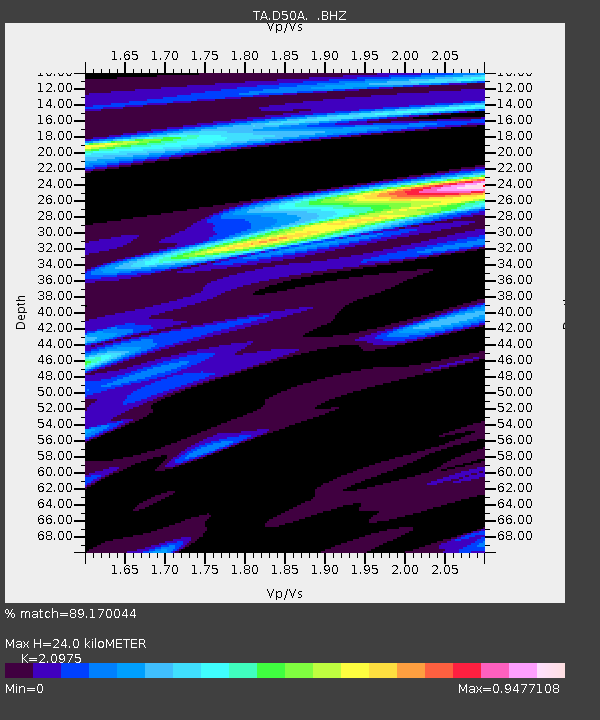
| Estimated Moho Depth: |
24.0 km |
| Estimated Crust Vp/Vs: |
2.10 |
| Assumed Crust Vp: |
6.622 km/s |
| Estimated Crust Vs: |
3.157 km/s |
| Estimated Crust Poisson's Ratio: |
0.35 |
|
| Radial Match: |
89.170044 % |
| Radial Bump: |
302 |
| Transverse Match: |
61.633293 % |
| Transverse Bump: |
400 |
| SOD ConfigId: |
769524 |
| Insert Time: |
2014-08-10 02:30:50.095 +0000 |
| GWidth: |
2.5 |
| Max Bumps: |
400 |
| Tol: |
0.001 |
|
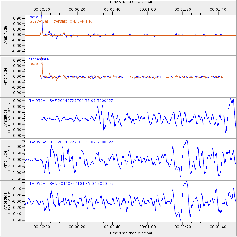
Signal To Noise
| Channel | StoN | STA | LTA |
| TA:D50A: :BHZ:20140727T01:35:07.500012Z | 8.827632 | 5.1337315E-7 | 5.815525E-8 |
| TA:D50A: :BHN:20140727T01:35:07.500012Z | 2.056057 | 1.4765983E-7 | 7.181699E-8 |
| TA:D50A: :BHE:20140727T01:35:07.500012Z | 4.727048 | 3.214502E-7 | 6.8002315E-8 |
| Arrivals |
| Ps | 4.3 SECOND |
| PpPs | 10 SECOND |
| PsPs/PpSs | 15 SECOND |


