You are here: Home > Network List > TA - USArray Transportable Network (new EarthScope stations) Stations List
> Station D51A Lot 18 Range III Mazenod Township, QC, CAN > Earthquake Result Viewer
D51A Lot 18 Range III Mazenod Township, QC, CAN - Earthquake Result Viewer
| Earthquake location: |
Northern Mid-Atlantic Ridge |
| Earthquake latitude/longitude: |
23.8/-45.6 |
| Earthquake time(UTC): |
2014/07/27 (208) 01:28:38 GMT |
| Earthquake Depth: |
10 km |
| Earthquake Magnitude: |
5.6 MB, 6.0 MWB, 6.6 MI |
| Earthquake Catalog/Contributor: |
NEIC PDE/NEIC COMCAT |
|
| Network: |
TA USArray Transportable Network (new EarthScope stations) |
| Station: |
D51A Lot 18 Range III Mazenod Township, QC, CAN |
| Lat/Lon: |
47.09 N/79.37 W |
| Elevation: |
282 m |
|
| Distance: |
35.6 deg |
| Az: |
319.313 deg |
| Baz: |
119.053 deg |
| Ray Param: |
0.07714253 |
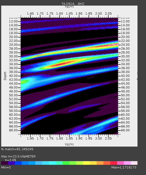
| Estimated Moho Depth: |
23.5 km |
| Estimated Crust Vp/Vs: |
2.09 |
| Assumed Crust Vp: |
6.622 km/s |
| Estimated Crust Vs: |
3.169 km/s |
| Estimated Crust Poisson's Ratio: |
0.35 |
|
| Radial Match: |
91.345245 % |
| Radial Bump: |
265 |
| Transverse Match: |
66.37883 % |
| Transverse Bump: |
400 |
| SOD ConfigId: |
769524 |
| Insert Time: |
2014-08-10 02:30:54.888 +0000 |
| GWidth: |
2.5 |
| Max Bumps: |
400 |
| Tol: |
0.001 |
|
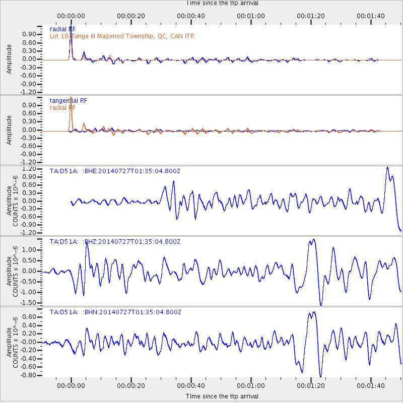
Signal To Noise
| Channel | StoN | STA | LTA |
| TA:D51A: :BHZ:20140727T01:35:04.800Z | 8.42859 | 5.4265826E-7 | 6.4383045E-8 |
| TA:D51A: :BHN:20140727T01:35:04.800Z | 2.1360476 | 1.5021381E-7 | 7.032325E-8 |
| TA:D51A: :BHE:20140727T01:35:04.800Z | 5.8468685 | 3.5804314E-7 | 6.123673E-8 |
| Arrivals |
| Ps | 4.1 SECOND |
| PpPs | 10 SECOND |
| PsPs/PpSs | 14 SECOND |


