You are here: Home > Network List > TA - USArray Transportable Network (new EarthScope stations) Stations List
> Station Q24A Divide, CO, USA > Earthquake Result Viewer
Q24A Divide, CO, USA - Earthquake Result Viewer
| Earthquake location: |
Tonga Islands |
| Earthquake latitude/longitude: |
-15.2/-173.2 |
| Earthquake time(UTC): |
2015/04/07 (097) 00:46:18 GMT |
| Earthquake Depth: |
10 km |
| Earthquake Magnitude: |
5.8 MB |
| Earthquake Catalog/Contributor: |
NEIC PDE/NEIC ALERT |
|
| Network: |
TA USArray Transportable Network (new EarthScope stations) |
| Station: |
Q24A Divide, CO, USA |
| Lat/Lon: |
38.96 N/105.15 W |
| Elevation: |
2775 m |
|
| Distance: |
83.2 deg |
| Az: |
46.743 deg |
| Baz: |
244.412 deg |
| Ray Param: |
0.046337787 |
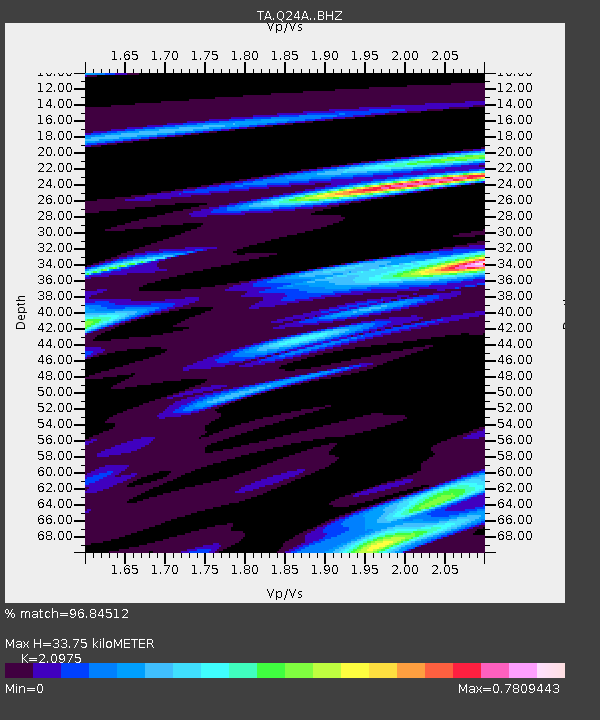
| Estimated Moho Depth: |
33.75 km |
| Estimated Crust Vp/Vs: |
2.10 |
| Assumed Crust Vp: |
6.159 km/s |
| Estimated Crust Vs: |
2.936 km/s |
| Estimated Crust Poisson's Ratio: |
0.35 |
|
| Radial Match: |
96.84512 % |
| Radial Bump: |
400 |
| Transverse Match: |
92.933495 % |
| Transverse Bump: |
400 |
| SOD ConfigId: |
7422571 |
| Insert Time: |
2019-04-18 03:03:08.036 +0000 |
| GWidth: |
2.5 |
| Max Bumps: |
400 |
| Tol: |
0.001 |
|
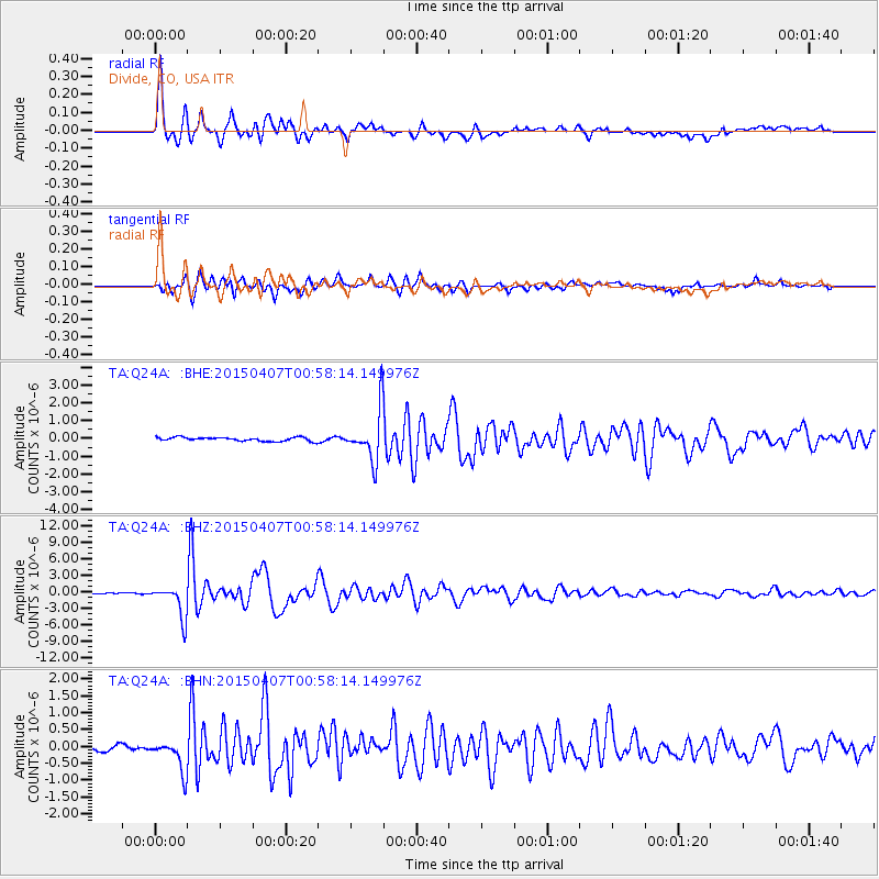
Signal To Noise
| Channel | StoN | STA | LTA |
| TA:Q24A: :BHZ:20150407T00:58:14.149976Z | 21.578857 | 2.9320342E-6 | 1.3587533E-7 |
| TA:Q24A: :BHN:20150407T00:58:14.149976Z | 6.198735 | 4.7305923E-7 | 7.6315445E-8 |
| TA:Q24A: :BHE:20150407T00:58:14.149976Z | 8.372641 | 8.420256E-7 | 1.005687E-7 |
| Arrivals |
| Ps | 6.1 SECOND |
| PpPs | 17 SECOND |
| PsPs/PpSs | 23 SECOND |


