You are here: Home > Network List > TA - USArray Transportable Network (new EarthScope stations) Stations List
> Station E51A G1948 Merrick Township, ON, CAN > Earthquake Result Viewer
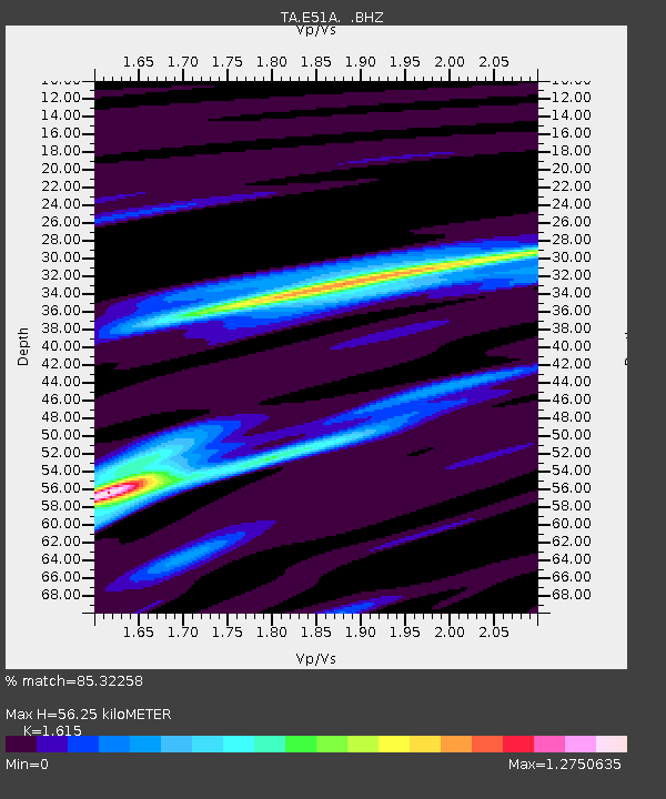
E51A G1948 Merrick Township, ON, CAN - Earthquake Result Viewer
| Earthquake location: |
Northern Mid-Atlantic Ridge |
| Earthquake latitude/longitude: |
23.8/-45.6 |
| Earthquake time(UTC): |
2014/07/27 (208) 01:28:38 GMT |
| Earthquake Depth: |
10 km |
| Earthquake Magnitude: |
5.6 MB, 6.0 MWB, 6.6 MI |
| Earthquake Catalog/Contributor: |
NEIC PDE/NEIC COMCAT |
|
| Network: |
TA USArray Transportable Network (new EarthScope stations) |
| Station: |
E51A G1948 Merrick Township, ON, CAN |
| Lat/Lon: |
46.53 N/79.49 W |
| Elevation: |
369 m |
|
| Distance: |
35.4 deg |
| Az: |
318.403 deg |
| Baz: |
118.226 deg |
| Ray Param: |
0.07724789 |
| Estimated Moho Depth: |
56.25 km |
| Estimated Crust Vp/Vs: |
1.62 |
| Assumed Crust Vp: |
6.622 km/s |
| Estimated Crust Vs: |
4.1 km/s |
| Estimated Crust Poisson's Ratio: |
0.19 |
|
| Radial Match: |
85.32258 % |
| Radial Bump: |
205 |
| Transverse Match: |
73.135956 % |
| Transverse Bump: |
400 |
| SOD ConfigId: |
769524 |
| Insert Time: |
2014-08-10 02:31:51.580 +0000 |
| GWidth: |
2.5 |
| Max Bumps: |
400 |
| Tol: |
0.001 |
|

Signal To Noise
| Channel | StoN | STA | LTA |
| TA:E51A: :BHZ:20140727T01:35:03.125012Z | 5.506672 | 4.2992437E-7 | 7.8073356E-8 |
| TA:E51A: :BHN:20140727T01:35:03.125012Z | 1.6807364 | 1.4069032E-7 | 8.370754E-8 |
| TA:E51A: :BHE:20140727T01:35:03.125012Z | 5.8821397 | 3.038071E-7 | 5.164908E-8 |
| Arrivals |
| Ps | 5.7 SECOND |
| PpPs | 20 SECOND |
| PsPs/PpSs | 26 SECOND |


