You are here: Home > Network List > TA - USArray Transportable Network (new EarthScope stations) Stations List
> Station W41B Gary Mavity, Velonia, AR, USA > Earthquake Result Viewer
W41B Gary Mavity, Velonia, AR, USA - Earthquake Result Viewer
| Earthquake location: |
Tonga Islands |
| Earthquake latitude/longitude: |
-15.2/-173.2 |
| Earthquake time(UTC): |
2015/04/07 (097) 00:46:18 GMT |
| Earthquake Depth: |
10 km |
| Earthquake Magnitude: |
5.8 MB |
| Earthquake Catalog/Contributor: |
NEIC PDE/NEIC ALERT |
|
| Network: |
TA USArray Transportable Network (new EarthScope stations) |
| Station: |
W41B Gary Mavity, Velonia, AR, USA |
| Lat/Lon: |
35.17 N/92.25 W |
| Elevation: |
95 m |
|
| Distance: |
91.5 deg |
| Az: |
54.032 deg |
| Baz: |
252.52 deg |
| Ray Param: |
0.04160113 |
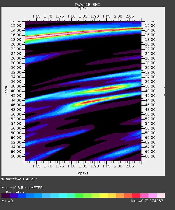
| Estimated Moho Depth: |
16.5 km |
| Estimated Crust Vp/Vs: |
1.65 |
| Assumed Crust Vp: |
6.498 km/s |
| Estimated Crust Vs: |
3.944 km/s |
| Estimated Crust Poisson's Ratio: |
0.21 |
|
| Radial Match: |
91.48225 % |
| Radial Bump: |
364 |
| Transverse Match: |
79.335655 % |
| Transverse Bump: |
307 |
| SOD ConfigId: |
7422571 |
| Insert Time: |
2019-04-18 03:03:17.839 +0000 |
| GWidth: |
2.5 |
| Max Bumps: |
400 |
| Tol: |
0.001 |
|

Signal To Noise
| Channel | StoN | STA | LTA |
| TA:W41B: :BHZ:20150407T00:58:53.724988Z | 19.567163 | 1.6066256E-6 | 8.210825E-8 |
| TA:W41B: :BHN:20150407T00:58:53.724988Z | 0.5853041 | 4.5063157E-8 | 7.699102E-8 |
| TA:W41B: :BHE:20150407T00:58:53.724988Z | 2.7736392 | 3.0527363E-7 | 1.1006249E-7 |
| Arrivals |
| Ps | 1.7 SECOND |
| PpPs | 6.6 SECOND |
| PsPs/PpSs | 8.3 SECOND |


