You are here: Home > Network List > TA - USArray Transportable Network (new EarthScope stations) Stations List
> Station WHTX Lake Whitney, Meridian, TX, USA > Earthquake Result Viewer
WHTX Lake Whitney, Meridian, TX, USA - Earthquake Result Viewer
| Earthquake location: |
Tonga Islands |
| Earthquake latitude/longitude: |
-15.2/-173.2 |
| Earthquake time(UTC): |
2015/04/07 (097) 00:46:18 GMT |
| Earthquake Depth: |
10 km |
| Earthquake Magnitude: |
5.8 MB |
| Earthquake Catalog/Contributor: |
NEIC PDE/NEIC ALERT |
|
| Network: |
TA USArray Transportable Network (new EarthScope stations) |
| Station: |
WHTX Lake Whitney, Meridian, TX, USA |
| Lat/Lon: |
31.99 N/97.46 W |
| Elevation: |
190 m |
|
| Distance: |
86.3 deg |
| Az: |
55.624 deg |
| Baz: |
249.681 deg |
| Ray Param: |
0.044142943 |
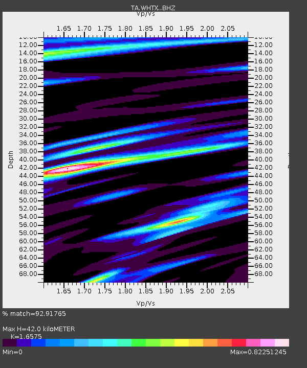
| Estimated Moho Depth: |
42.0 km |
| Estimated Crust Vp/Vs: |
1.66 |
| Assumed Crust Vp: |
6.347 km/s |
| Estimated Crust Vs: |
3.829 km/s |
| Estimated Crust Poisson's Ratio: |
0.21 |
|
| Radial Match: |
92.91765 % |
| Radial Bump: |
400 |
| Transverse Match: |
84.85536 % |
| Transverse Bump: |
400 |
| SOD ConfigId: |
7422571 |
| Insert Time: |
2019-04-18 03:03:20.407 +0000 |
| GWidth: |
2.5 |
| Max Bumps: |
400 |
| Tol: |
0.001 |
|
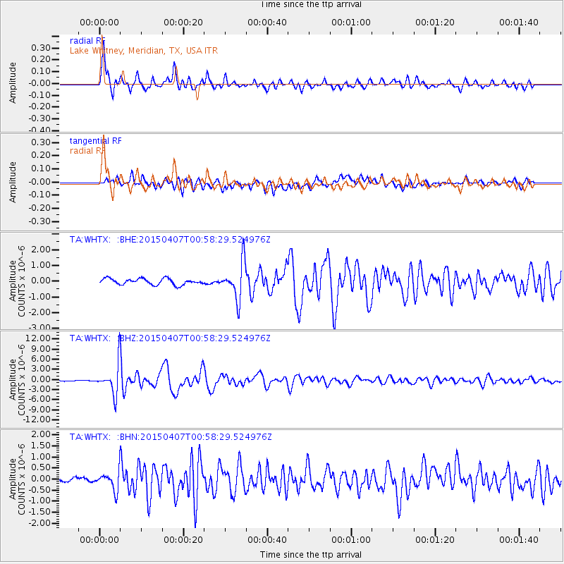
Signal To Noise
| Channel | StoN | STA | LTA |
| TA:WHTX: :BHZ:20150407T00:58:29.524976Z | 40.40347 | 4.8431752E-6 | 1.1987028E-7 |
| TA:WHTX: :BHN:20150407T00:58:29.524976Z | 6.593512 | 4.6857244E-7 | 7.1065685E-8 |
| TA:WHTX: :BHE:20150407T00:58:29.524976Z | 4.899042 | 9.479881E-7 | 1.9350479E-7 |
| Arrivals |
| Ps | 4.5 SECOND |
| PpPs | 17 SECOND |
| PsPs/PpSs | 22 SECOND |


