You are here: Home > Network List > TA - USArray Transportable Network (new EarthScope stations) Stations List
> Station X43A Marvell, AR, USA > Earthquake Result Viewer
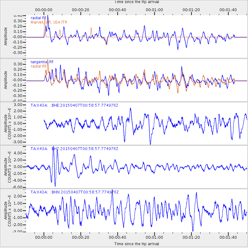
X43A Marvell, AR, USA - Earthquake Result Viewer
*The percent match for this event was below the threshold and hence no stack was calculated.
| Earthquake location: |
Tonga Islands |
| Earthquake latitude/longitude: |
-15.2/-173.2 |
| Earthquake time(UTC): |
2015/04/07 (097) 00:46:18 GMT |
| Earthquake Depth: |
10 km |
| Earthquake Magnitude: |
5.8 MB |
| Earthquake Catalog/Contributor: |
NEIC PDE/NEIC ALERT |
|
| Network: |
TA USArray Transportable Network (new EarthScope stations) |
| Station: |
X43A Marvell, AR, USA |
| Lat/Lon: |
34.52 N/90.88 W |
| Elevation: |
53 m |
|
| Distance: |
92.3 deg |
| Az: |
54.988 deg |
| Baz: |
253.266 deg |
| Ray Param: |
$rayparam |
*The percent match for this event was below the threshold and hence was not used in the summary stack. |
|
| Radial Match: |
67.4085 % |
| Radial Bump: |
400 |
| Transverse Match: |
64.98876 % |
| Transverse Bump: |
271 |
| SOD ConfigId: |
7422571 |
| Insert Time: |
2019-04-18 03:03:21.665 +0000 |
| GWidth: |
2.5 |
| Max Bumps: |
400 |
| Tol: |
0.001 |
|
Signal To Noise
| Channel | StoN | STA | LTA |
| TA:X43A: :BHZ:20150407T00:58:57.774976Z | 6.051571 | 1.6170621E-6 | 2.672136E-7 |
| TA:X43A: :BHN:20150407T00:58:57.774976Z | 0.5572905 | 3.460049E-7 | 6.208699E-7 |
| TA:X43A: :BHE:20150407T00:58:57.774976Z | 1.3682702 | 6.62842E-7 | 4.84438E-7 |
| Arrivals |
| Ps | |
| PpPs | |
| PsPs/PpSs | |


