You are here: Home > Network List > TA - USArray Transportable Network (new EarthScope stations) Stations List
> Station G55A Calabogie, ON, CAN > Earthquake Result Viewer
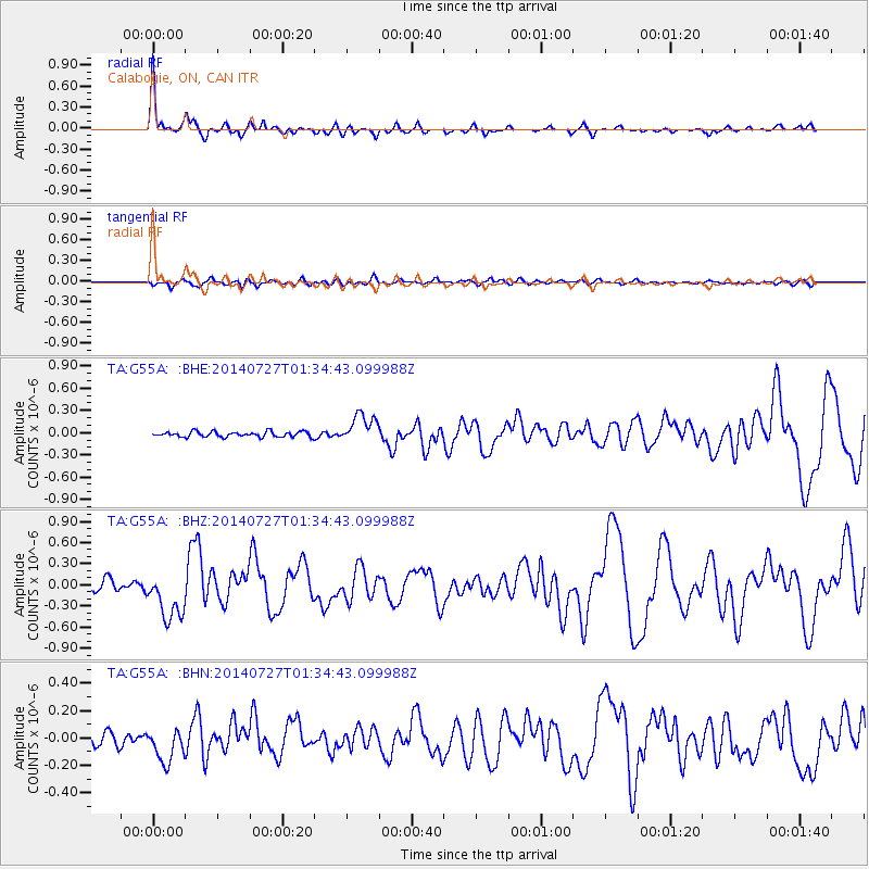
G55A Calabogie, ON, CAN - Earthquake Result Viewer

| Earthquake location: |
Northern Mid-Atlantic Ridge |
| Earthquake latitude/longitude: |
23.8/-45.6 |
| Earthquake time(UTC): |
2014/07/27 (208) 01:28:38 GMT |
| Earthquake Depth: |
10 km |
| Earthquake Magnitude: |
5.6 MB, 6.0 MWB, 6.6 MI |
| Earthquake Catalog/Contributor: |
NEIC PDE/NEIC COMCAT |
|
| Network: |
TA USArray Transportable Network (new EarthScope stations) |
| Station: |
G55A Calabogie, ON, CAN |
| Lat/Lon: |
45.25 N/76.72 W |
| Elevation: |
228 m |
|
| Distance: |
33.1 deg |
| Az: |
318.089 deg |
| Baz: |
119.951 deg |
| Ray Param: |
0.07837401 |
| Estimated Moho Depth: |
45.5 km |
| Estimated Crust Vp/Vs: |
1.68 |
| Assumed Crust Vp: |
6.577 km/s |
| Estimated Crust Vs: |
3.921 km/s |
| Estimated Crust Poisson's Ratio: |
0.22 |
|
| Radial Match: |
84.526695 % |
| Radial Bump: |
358 |
| Transverse Match: |
55.814484 % |
| Transverse Bump: |
400 |
| SOD ConfigId: |
769524 |
| Insert Time: |
2014-08-10 02:33:28.342 +0000 |
| GWidth: |
2.5 |
| Max Bumps: |
400 |
| Tol: |
0.001 |
|
Signal To Noise
| Channel | StoN | STA | LTA |
| TA:G55A: :BHZ:20140727T01:34:43.099988Z | 4.5762196 | 3.482273E-7 | 7.609497E-8 |
| TA:G55A: :BHN:20140727T01:34:43.099988Z | 2.3013403 | 1.2639615E-7 | 5.492284E-8 |
| TA:G55A: :BHE:20140727T01:34:43.099988Z | 5.285272 | 1.9021802E-7 | 3.59902E-8 |
| Arrivals |
| Ps | 5.1 SECOND |
| PpPs | 17 SECOND |
| PsPs/PpSs | 22 SECOND |


