You are here: Home > Network List > TA - USArray Transportable Network (new EarthScope stations) Stations List
> Station G57A Newington, ON, CAN > Earthquake Result Viewer
G57A Newington, ON, CAN - Earthquake Result Viewer
| Earthquake location: |
Northern Mid-Atlantic Ridge |
| Earthquake latitude/longitude: |
23.8/-45.6 |
| Earthquake time(UTC): |
2014/07/27 (208) 01:28:38 GMT |
| Earthquake Depth: |
10 km |
| Earthquake Magnitude: |
5.6 MB, 6.0 MWB, 6.6 MI |
| Earthquake Catalog/Contributor: |
NEIC PDE/NEIC COMCAT |
|
| Network: |
TA USArray Transportable Network (new EarthScope stations) |
| Station: |
G57A Newington, ON, CAN |
| Lat/Lon: |
45.10 N/74.99 W |
| Elevation: |
96 m |
|
| Distance: |
31.9 deg |
| Az: |
319.023 deg |
| Baz: |
121.965 deg |
| Ray Param: |
0.07885942 |
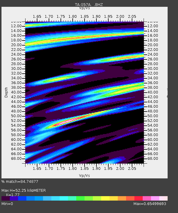
| Estimated Moho Depth: |
52.25 km |
| Estimated Crust Vp/Vs: |
1.77 |
| Assumed Crust Vp: |
6.419 km/s |
| Estimated Crust Vs: |
3.627 km/s |
| Estimated Crust Poisson's Ratio: |
0.27 |
|
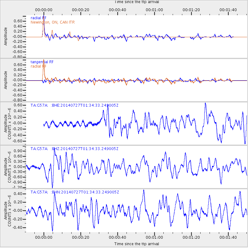
| Radial Match: |
84.74877 % |
| Radial Bump: |
315 |
| Transverse Match: |
75.07152 % |
| Transverse Bump: |
378 |
| SOD ConfigId: |
769524 |
| Insert Time: |
2014-08-10 02:33:36.091 +0000 |
| GWidth: |
2.5 |
| Max Bumps: |
400 |
| Tol: |
0.001 |
|
Signal To Noise
| Channel | StoN | STA | LTA |
| TA:G57A: :BHZ:20140727T01:34:33.249005Z | 7.2432 | 5.1143553E-7 | 7.060906E-8 |
| TA:G57A: :BHN:20140727T01:34:33.249005Z | 3.3661306 | 1.7816305E-7 | 5.2928147E-8 |
| TA:G57A: :BHE:20140727T01:34:33.249005Z | 4.3843493 | 2.581245E-7 | 5.8874072E-8 |
| Arrivals |
| Ps | 6.8 SECOND |
| PpPs | 21 SECOND |
| PsPs/PpSs | 28 SECOND |


