You are here: Home > Network List > TA - USArray Transportable Network (new EarthScope stations) Stations List
> Station H58A Gabriels, NY, USA > Earthquake Result Viewer
H58A Gabriels, NY, USA - Earthquake Result Viewer
| Earthquake location: |
Northern Mid-Atlantic Ridge |
| Earthquake latitude/longitude: |
23.8/-45.6 |
| Earthquake time(UTC): |
2014/07/27 (208) 01:28:38 GMT |
| Earthquake Depth: |
10 km |
| Earthquake Magnitude: |
5.6 MB, 6.0 MWB, 6.6 MI |
| Earthquake Catalog/Contributor: |
NEIC PDE/NEIC COMCAT |
|
| Network: |
TA USArray Transportable Network (new EarthScope stations) |
| Station: |
H58A Gabriels, NY, USA |
| Lat/Lon: |
44.42 N/74.18 W |
| Elevation: |
537 m |
|
| Distance: |
31.1 deg |
| Az: |
318.493 deg |
| Baz: |
122.078 deg |
| Ray Param: |
0.07915834 |
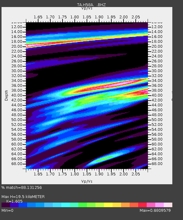
| Estimated Moho Depth: |
19.5 km |
| Estimated Crust Vp/Vs: |
1.61 |
| Assumed Crust Vp: |
6.419 km/s |
| Estimated Crust Vs: |
4.0 km/s |
| Estimated Crust Poisson's Ratio: |
0.18 |
|
| Radial Match: |
88.131256 % |
| Radial Bump: |
335 |
| Transverse Match: |
70.284454 % |
| Transverse Bump: |
400 |
| SOD ConfigId: |
769524 |
| Insert Time: |
2014-08-10 02:34:40.109 +0000 |
| GWidth: |
2.5 |
| Max Bumps: |
400 |
| Tol: |
0.001 |
|

Signal To Noise
| Channel | StoN | STA | LTA |
| TA:H58A: :BHZ:20140727T01:34:25.775006Z | 5.898323 | 5.174222E-7 | 8.772361E-8 |
| TA:H58A: :BHN:20140727T01:34:25.775006Z | 3.2236013 | 1.8348437E-7 | 5.6919067E-8 |
| TA:H58A: :BHE:20140727T01:34:25.775006Z | 5.895134 | 2.8679173E-7 | 4.864889E-8 |
| Arrivals |
| Ps | 2.0 SECOND |
| PpPs | 7.2 SECOND |
| PsPs/PpSs | 9.2 SECOND |


