You are here: Home > Network List > TA - USArray Transportable Network (new EarthScope stations) Stations List
> Station M53A WI Miller and Sons, Farmdale, OH, USA > Earthquake Result Viewer
M53A WI Miller and Sons, Farmdale, OH, USA - Earthquake Result Viewer
| Earthquake location: |
Northern Mid-Atlantic Ridge |
| Earthquake latitude/longitude: |
23.8/-45.6 |
| Earthquake time(UTC): |
2014/07/27 (208) 01:28:38 GMT |
| Earthquake Depth: |
10 km |
| Earthquake Magnitude: |
5.6 MB, 6.0 MWB, 6.6 MI |
| Earthquake Catalog/Contributor: |
NEIC PDE/NEIC COMCAT |
|
| Network: |
TA USArray Transportable Network (new EarthScope stations) |
| Station: |
M53A WI Miller and Sons, Farmdale, OH, USA |
| Lat/Lon: |
41.44 N/80.68 W |
| Elevation: |
334 m |
|
| Distance: |
34.1 deg |
| Az: |
309.631 deg |
| Baz: |
110.193 deg |
| Ray Param: |
0.077911936 |
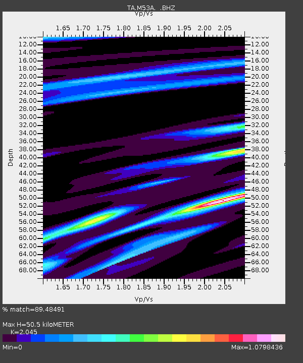
| Estimated Moho Depth: |
50.5 km |
| Estimated Crust Vp/Vs: |
2.05 |
| Assumed Crust Vp: |
6.483 km/s |
| Estimated Crust Vs: |
3.17 km/s |
| Estimated Crust Poisson's Ratio: |
0.34 |
|
| Radial Match: |
89.48491 % |
| Radial Bump: |
256 |
| Transverse Match: |
68.93873 % |
| Transverse Bump: |
400 |
| SOD ConfigId: |
769524 |
| Insert Time: |
2014-08-10 02:38:05.186 +0000 |
| GWidth: |
2.5 |
| Max Bumps: |
400 |
| Tol: |
0.001 |
|
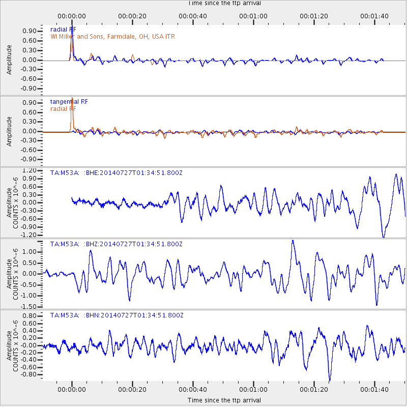
Signal To Noise
| Channel | StoN | STA | LTA |
| TA:M53A: :BHZ:20140727T01:34:51.800Z | 4.433844 | 4.0865345E-7 | 9.216684E-8 |
| TA:M53A: :BHN:20140727T01:34:51.800Z | 1.6852105 | 1.07357366E-7 | 6.370561E-8 |
| TA:M53A: :BHE:20140727T01:34:51.800Z | 2.18846 | 1.8813287E-7 | 8.5965866E-8 |
| Arrivals |
| Ps | 8.7 SECOND |
| PpPs | 22 SECOND |
| PsPs/PpSs | 31 SECOND |


