You are here: Home > Network List > TA - USArray Transportable Network (new EarthScope stations) Stations List
> Station M56A Emporium, PA, USA > Earthquake Result Viewer
M56A Emporium, PA, USA - Earthquake Result Viewer
| Earthquake location: |
Northern Mid-Atlantic Ridge |
| Earthquake latitude/longitude: |
23.8/-45.6 |
| Earthquake time(UTC): |
2014/07/27 (208) 01:28:38 GMT |
| Earthquake Depth: |
10 km |
| Earthquake Magnitude: |
5.6 MB, 6.0 MWB, 6.6 MI |
| Earthquake Catalog/Contributor: |
NEIC PDE/NEIC COMCAT |
|
| Network: |
TA USArray Transportable Network (new EarthScope stations) |
| Station: |
M56A Emporium, PA, USA |
| Lat/Lon: |
41.48 N/78.18 W |
| Elevation: |
493 m |
|
| Distance: |
32.4 deg |
| Az: |
310.964 deg |
| Baz: |
112.952 deg |
| Ray Param: |
0.07868738 |
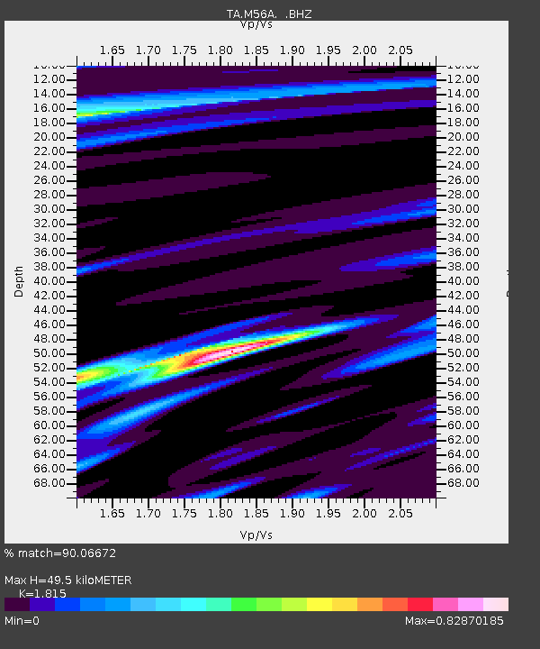
| Estimated Moho Depth: |
49.5 km |
| Estimated Crust Vp/Vs: |
1.82 |
| Assumed Crust Vp: |
6.121 km/s |
| Estimated Crust Vs: |
3.372 km/s |
| Estimated Crust Poisson's Ratio: |
0.28 |
|
| Radial Match: |
90.06672 % |
| Radial Bump: |
334 |
| Transverse Match: |
58.511024 % |
| Transverse Bump: |
400 |
| SOD ConfigId: |
769524 |
| Insert Time: |
2014-08-10 02:38:19.770 +0000 |
| GWidth: |
2.5 |
| Max Bumps: |
400 |
| Tol: |
0.001 |
|

Signal To Noise
| Channel | StoN | STA | LTA |
| TA:M56A: :BHZ:20140727T01:34:36.775006Z | 2.7338998 | 4.0445127E-7 | 1.4793932E-7 |
| TA:M56A: :BHN:20140727T01:34:36.775006Z | 0.8221205 | 8.48323E-8 | 1.0318719E-7 |
| TA:M56A: :BHE:20140727T01:34:36.775006Z | 2.7273293 | 2.0791055E-7 | 7.623229E-8 |
| Arrivals |
| Ps | 7.1 SECOND |
| PpPs | 21 SECOND |
| PsPs/PpSs | 28 SECOND |


