You are here: Home > Network List > TA - USArray Transportable Network (new EarthScope stations) Stations List
> Station O51A Pataskala, OH, USA > Earthquake Result Viewer
O51A Pataskala, OH, USA - Earthquake Result Viewer

| Earthquake location: |
Northern Mid-Atlantic Ridge |
| Earthquake latitude/longitude: |
23.8/-45.6 |
| Earthquake time(UTC): |
2014/07/27 (208) 01:28:38 GMT |
| Earthquake Depth: |
10 km |
| Earthquake Magnitude: |
5.6 MB, 6.0 MWB, 6.6 MI |
| Earthquake Catalog/Contributor: |
NEIC PDE/NEIC COMCAT |
|
| Network: |
TA USArray Transportable Network (new EarthScope stations) |
| Station: |
O51A Pataskala, OH, USA |
| Lat/Lon: |
40.15 N/82.61 W |
| Elevation: |
380 m |
|
| Distance: |
35.1 deg |
| Az: |
306.659 deg |
| Baz: |
106.489 deg |
| Ray Param: |
0.077417284 |
| Estimated Moho Depth: |
47.5 km |
| Estimated Crust Vp/Vs: |
1.75 |
| Assumed Crust Vp: |
6.498 km/s |
| Estimated Crust Vs: |
3.724 km/s |
| Estimated Crust Poisson's Ratio: |
0.26 |
|
| Radial Match: |
92.01147 % |
| Radial Bump: |
269 |
| Transverse Match: |
64.40892 % |
| Transverse Bump: |
400 |
| SOD ConfigId: |
769524 |
| Insert Time: |
2014-08-10 02:39:34.181 +0000 |
| GWidth: |
2.5 |
| Max Bumps: |
400 |
| Tol: |
0.001 |
|
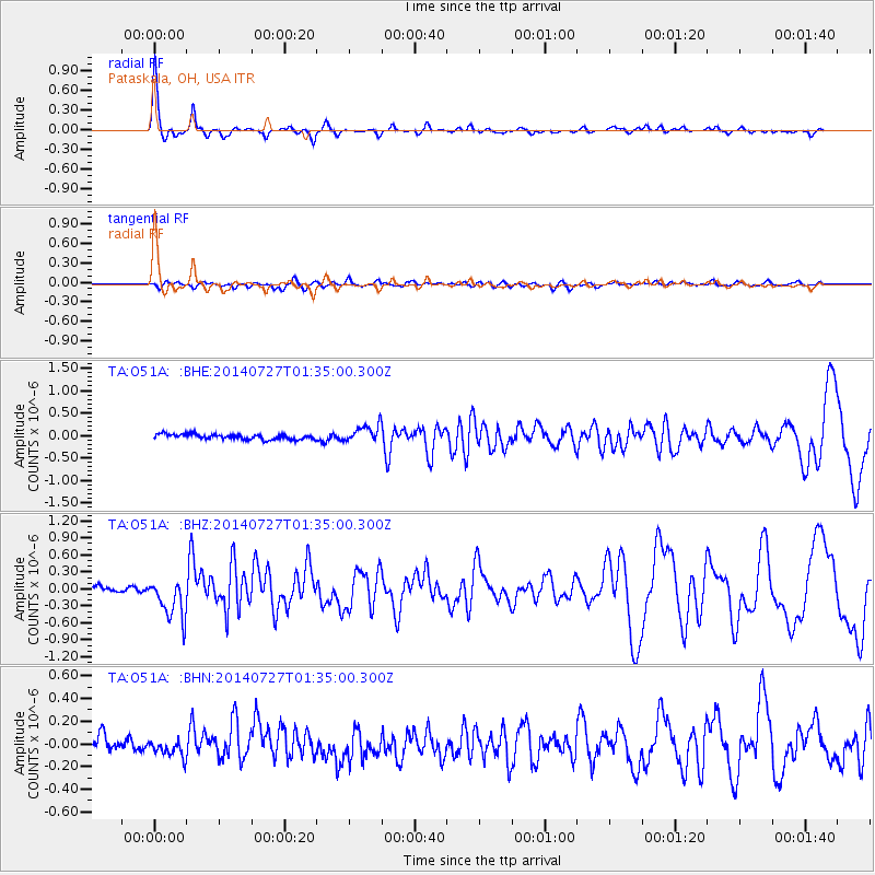
Signal To Noise
| Channel | StoN | STA | LTA |
| TA:O51A: :BHZ:20140727T01:35:00.300Z | 5.347764 | 3.6507055E-7 | 6.826601E-8 |
| TA:O51A: :BHN:20140727T01:35:00.300Z | 1.0944418 | 7.21813E-8 | 6.595262E-8 |
| TA:O51A: :BHE:20140727T01:35:00.300Z | 3.4234834 | 1.9057603E-7 | 5.5667286E-8 |
| Arrivals |
| Ps | 5.9 SECOND |
| PpPs | 19 SECOND |
| PsPs/PpSs | 24 SECOND |


