You are here: Home > Network List > TA - USArray Transportable Network (new EarthScope stations) Stations List
> Station O56A Blue Knob State Park, Imler, PA, USA > Earthquake Result Viewer
O56A Blue Knob State Park, Imler, PA, USA - Earthquake Result Viewer

| Earthquake location: |
Northern Mid-Atlantic Ridge |
| Earthquake latitude/longitude: |
23.8/-45.6 |
| Earthquake time(UTC): |
2014/07/27 (208) 01:28:38 GMT |
| Earthquake Depth: |
10 km |
| Earthquake Magnitude: |
5.6 MB, 6.0 MWB, 6.6 MI |
| Earthquake Catalog/Contributor: |
NEIC PDE/NEIC COMCAT |
|
| Network: |
TA USArray Transportable Network (new EarthScope stations) |
| Station: |
O56A Blue Knob State Park, Imler, PA, USA |
| Lat/Lon: |
40.27 N/78.57 W |
| Elevation: |
684 m |
|
| Distance: |
32.2 deg |
| Az: |
308.65 deg |
| Baz: |
110.745 deg |
| Ray Param: |
0.07876471 |
| Estimated Moho Depth: |
43.75 km |
| Estimated Crust Vp/Vs: |
2.04 |
| Assumed Crust Vp: |
6.121 km/s |
| Estimated Crust Vs: |
3.0 km/s |
| Estimated Crust Poisson's Ratio: |
0.34 |
|
| Radial Match: |
90.351006 % |
| Radial Bump: |
400 |
| Transverse Match: |
81.558815 % |
| Transverse Bump: |
400 |
| SOD ConfigId: |
769524 |
| Insert Time: |
2014-08-10 02:39:55.146 +0000 |
| GWidth: |
2.5 |
| Max Bumps: |
400 |
| Tol: |
0.001 |
|
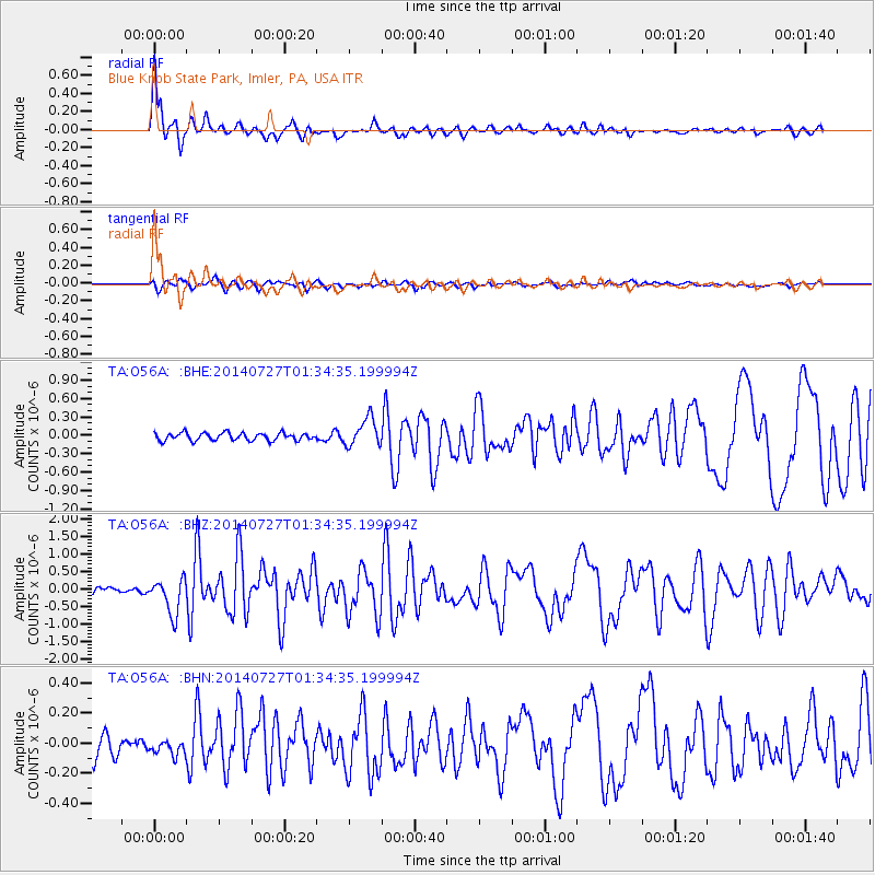
Signal To Noise
| Channel | StoN | STA | LTA |
| TA:O56A: :BHZ:20140727T01:34:35.199994Z | 5.233567 | 5.0588517E-7 | 9.666164E-8 |
| TA:O56A: :BHN:20140727T01:34:35.199994Z | 0.73629665 | 5.5906273E-8 | 7.592901E-8 |
| TA:O56A: :BHE:20140727T01:34:35.199994Z | 3.6948557 | 2.2706288E-7 | 6.145379E-8 |
| Arrivals |
| Ps | 7.9 SECOND |
| PpPs | 20 SECOND |
| PsPs/PpSs | 28 SECOND |


