You are here: Home > Network List > TA - USArray Transportable Network (new EarthScope stations) Stations List
> Station O57A Amberson, PA, USA > Earthquake Result Viewer
O57A Amberson, PA, USA - Earthquake Result Viewer
| Earthquake location: |
Northern Mid-Atlantic Ridge |
| Earthquake latitude/longitude: |
23.8/-45.6 |
| Earthquake time(UTC): |
2014/07/27 (208) 01:28:38 GMT |
| Earthquake Depth: |
10 km |
| Earthquake Magnitude: |
5.6 MB, 6.0 MWB, 6.6 MI |
| Earthquake Catalog/Contributor: |
NEIC PDE/NEIC COMCAT |
|
| Network: |
TA USArray Transportable Network (new EarthScope stations) |
| Station: |
O57A Amberson, PA, USA |
| Lat/Lon: |
40.21 N/77.64 W |
| Elevation: |
377 m |
|
| Distance: |
31.5 deg |
| Az: |
309.036 deg |
| Baz: |
111.673 deg |
| Ray Param: |
0.079056114 |
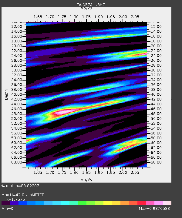
| Estimated Moho Depth: |
47.0 km |
| Estimated Crust Vp/Vs: |
1.76 |
| Assumed Crust Vp: |
6.121 km/s |
| Estimated Crust Vs: |
3.483 km/s |
| Estimated Crust Poisson's Ratio: |
0.26 |
|
| Radial Match: |
88.82307 % |
| Radial Bump: |
400 |
| Transverse Match: |
55.552094 % |
| Transverse Bump: |
400 |
| SOD ConfigId: |
769524 |
| Insert Time: |
2014-08-10 02:39:58.642 +0000 |
| GWidth: |
2.5 |
| Max Bumps: |
400 |
| Tol: |
0.001 |
|
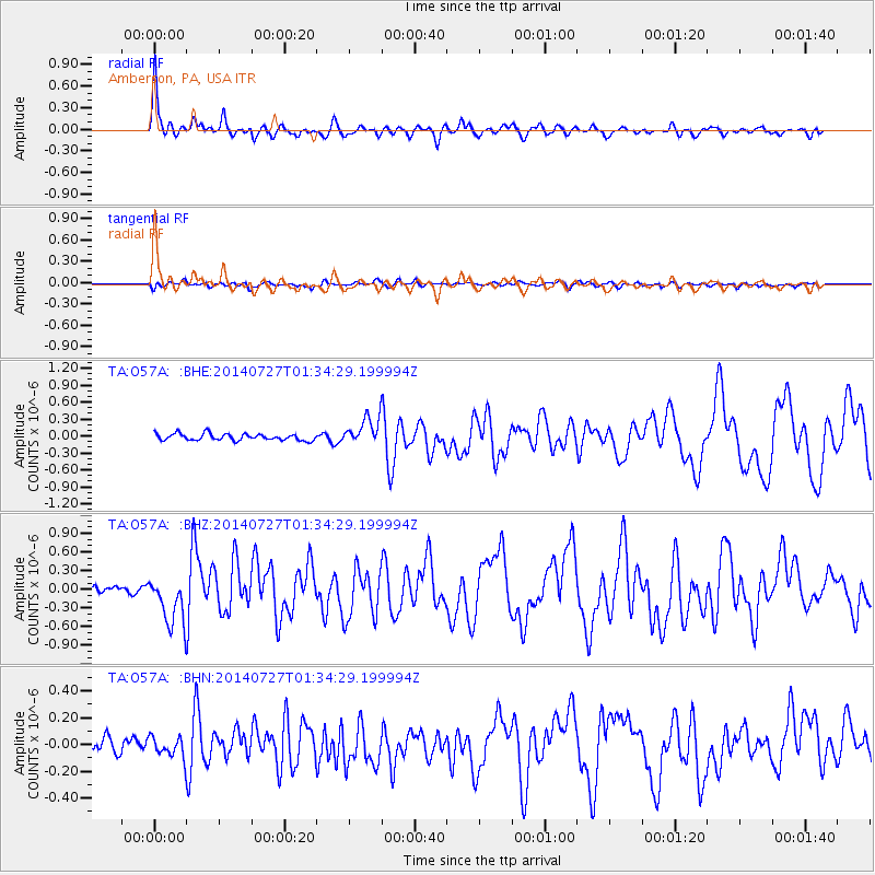
Signal To Noise
| Channel | StoN | STA | LTA |
| TA:O57A: :BHZ:20140727T01:34:29.199994Z | 5.6577587 | 3.898275E-7 | 6.89014E-8 |
| TA:O57A: :BHN:20140727T01:34:29.199994Z | 1.1751816 | 7.3104104E-8 | 6.2206645E-8 |
| TA:O57A: :BHE:20140727T01:34:29.199994Z | 4.0627 | 2.410933E-7 | 5.9343122E-8 |
| Arrivals |
| Ps | 6.3 SECOND |
| PpPs | 20 SECOND |
| PsPs/PpSs | 26 SECOND |


