You are here: Home > Network List > XD14 - Illuminating the architecture of the greater Mount St. Helens magmatic systems f Stations List
> Station MF09 "Mount St Helens, WA" > Earthquake Result Viewer
MF09 "Mount St Helens, WA" - Earthquake Result Viewer
| Earthquake location: |
Tonga Islands |
| Earthquake latitude/longitude: |
-15.2/-173.2 |
| Earthquake time(UTC): |
2015/04/07 (097) 00:46:18 GMT |
| Earthquake Depth: |
10 km |
| Earthquake Magnitude: |
5.8 MB |
| Earthquake Catalog/Contributor: |
NEIC PDE/NEIC ALERT |
|
| Network: |
XD Illuminating the architecture of the greater Mount St. Helens magmatic systems f |
| Station: |
MF09 "Mount St Helens, WA" |
| Lat/Lon: |
46.39 N/121.86 W |
| Elevation: |
1216 m |
|
| Distance: |
76.7 deg |
| Az: |
33.742 deg |
| Baz: |
230.783 deg |
| Ray Param: |
0.050786562 |
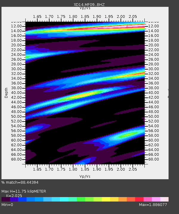
| Estimated Moho Depth: |
11.75 km |
| Estimated Crust Vp/Vs: |
2.03 |
| Assumed Crust Vp: |
6.597 km/s |
| Estimated Crust Vs: |
3.258 km/s |
| Estimated Crust Poisson's Ratio: |
0.34 |
|
| Radial Match: |
88.44394 % |
| Radial Bump: |
400 |
| Transverse Match: |
86.133766 % |
| Transverse Bump: |
400 |
| SOD ConfigId: |
7422571 |
| Insert Time: |
2019-04-18 03:05:07.265 +0000 |
| GWidth: |
2.5 |
| Max Bumps: |
400 |
| Tol: |
0.001 |
|

Signal To Noise
| Channel | StoN | STA | LTA |
| XD:MF09: :BHZ:20150407T00:57:39.365002Z | 21.66339 | 4.9464657E-6 | 2.2833294E-7 |
| XD:MF09: :BHN:20150407T00:57:39.365002Z | 7.724787 | 1.3310128E-6 | 1.7230413E-7 |
| XD:MF09: :BHE:20150407T00:57:39.365002Z | 4.7617316 | 1.2679203E-6 | 2.6627296E-7 |
| Arrivals |
| Ps | 1.9 SECOND |
| PpPs | 5.2 SECOND |
| PsPs/PpSs | 7.1 SECOND |


