You are here: Home > Network List > XD14 - Illuminating the architecture of the greater Mount St. Helens magmatic systems f Stations List
> Station MG06 "Mount St Helens, WA" > Earthquake Result Viewer
MG06 "Mount St Helens, WA" - Earthquake Result Viewer
| Earthquake location: |
Tonga Islands |
| Earthquake latitude/longitude: |
-15.2/-173.2 |
| Earthquake time(UTC): |
2015/04/07 (097) 00:46:18 GMT |
| Earthquake Depth: |
10 km |
| Earthquake Magnitude: |
5.8 MB |
| Earthquake Catalog/Contributor: |
NEIC PDE/NEIC ALERT |
|
| Network: |
XD Illuminating the architecture of the greater Mount St. Helens magmatic systems f |
| Station: |
MG06 "Mount St Helens, WA" |
| Lat/Lon: |
46.35 N/122.22 W |
| Elevation: |
1408 m |
|
| Distance: |
76.5 deg |
| Az: |
33.612 deg |
| Baz: |
230.496 deg |
| Ray Param: |
0.05093172 |
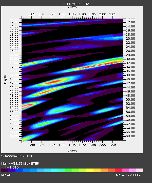
| Estimated Moho Depth: |
53.25 km |
| Estimated Crust Vp/Vs: |
1.62 |
| Assumed Crust Vp: |
6.566 km/s |
| Estimated Crust Vs: |
4.066 km/s |
| Estimated Crust Poisson's Ratio: |
0.19 |
|
| Radial Match: |
95.29461 % |
| Radial Bump: |
342 |
| Transverse Match: |
93.24149 % |
| Transverse Bump: |
400 |
| SOD ConfigId: |
7422571 |
| Insert Time: |
2019-04-18 03:05:10.863 +0000 |
| GWidth: |
2.5 |
| Max Bumps: |
400 |
| Tol: |
0.001 |
|

Signal To Noise
| Channel | StoN | STA | LTA |
| XD:MG06: :BHZ:20150407T00:57:38.149976Z | 32.377537 | 4.6162663E-6 | 1.425762E-7 |
| XD:MG06: :BHN:20150407T00:57:38.149976Z | 4.5902343 | 9.2766123E-7 | 2.0209453E-7 |
| XD:MG06: :BHE:20150407T00:57:38.149976Z | 11.159947 | 1.691165E-6 | 1.515388E-7 |
| Arrivals |
| Ps | 5.2 SECOND |
| PpPs | 20 SECOND |
| PsPs/PpSs | 26 SECOND |


