You are here: Home > Network List > TA - USArray Transportable Network (new EarthScope stations) Stations List
> Station R55A Marlinton, WV, USA > Earthquake Result Viewer
R55A Marlinton, WV, USA - Earthquake Result Viewer
| Earthquake location: |
Northern Mid-Atlantic Ridge |
| Earthquake latitude/longitude: |
23.8/-45.6 |
| Earthquake time(UTC): |
2014/07/27 (208) 01:28:38 GMT |
| Earthquake Depth: |
10 km |
| Earthquake Magnitude: |
5.6 MB, 6.0 MWB, 6.6 MI |
| Earthquake Catalog/Contributor: |
NEIC PDE/NEIC COMCAT |
|
| Network: |
TA USArray Transportable Network (new EarthScope stations) |
| Station: |
R55A Marlinton, WV, USA |
| Lat/Lon: |
38.28 N/80.12 W |
| Elevation: |
833 m |
|
| Distance: |
32.7 deg |
| Az: |
304.43 deg |
| Baz: |
106.203 deg |
| Ray Param: |
0.07854551 |
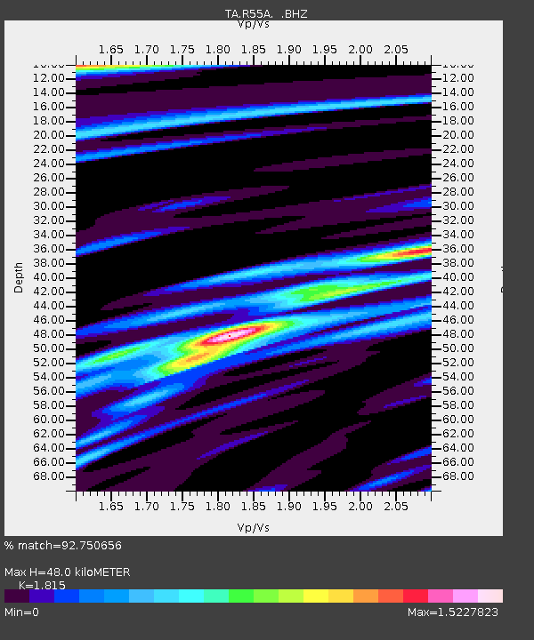
| Estimated Moho Depth: |
48.0 km |
| Estimated Crust Vp/Vs: |
1.82 |
| Assumed Crust Vp: |
6.207 km/s |
| Estimated Crust Vs: |
3.42 km/s |
| Estimated Crust Poisson's Ratio: |
0.28 |
|
| Radial Match: |
92.750656 % |
| Radial Bump: |
347 |
| Transverse Match: |
77.31027 % |
| Transverse Bump: |
376 |
| SOD ConfigId: |
769524 |
| Insert Time: |
2014-08-10 02:41:35.684 +0000 |
| GWidth: |
2.5 |
| Max Bumps: |
400 |
| Tol: |
0.001 |
|
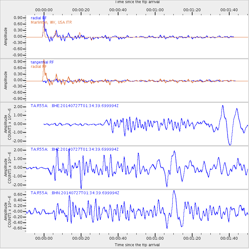
Signal To Noise
| Channel | StoN | STA | LTA |
| TA:R55A: :BHZ:20140727T01:34:39.699994Z | 3.6867442 | 3.0450087E-7 | 8.259344E-8 |
| TA:R55A: :BHN:20140727T01:34:39.699994Z | 1.1080348 | 5.5664998E-8 | 5.023759E-8 |
| TA:R55A: :BHE:20140727T01:34:39.699994Z | 3.2076945 | 2.193554E-7 | 6.8384125E-8 |
| Arrivals |
| Ps | 6.8 SECOND |
| PpPs | 20 SECOND |
| PsPs/PpSs | 27 SECOND |


