You are here: Home > Network List > TA - USArray Transportable Network (new EarthScope stations) Stations List
> Station R58A Rapidan, VA, USA > Earthquake Result Viewer
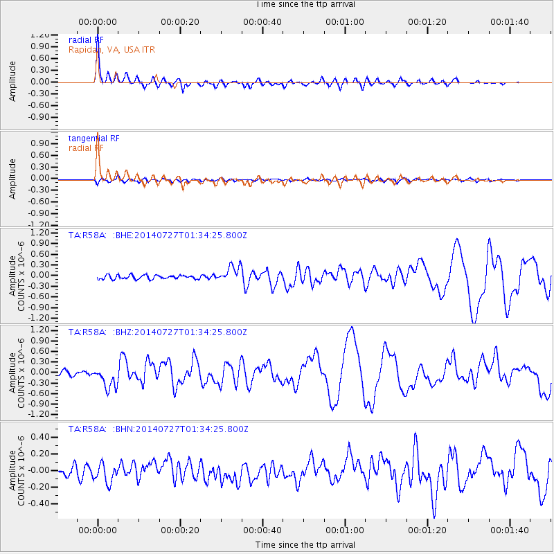
R58A Rapidan, VA, USA - Earthquake Result Viewer

| Earthquake location: |
Northern Mid-Atlantic Ridge |
| Earthquake latitude/longitude: |
23.8/-45.6 |
| Earthquake time(UTC): |
2014/07/27 (208) 01:28:38 GMT |
| Earthquake Depth: |
10 km |
| Earthquake Magnitude: |
5.6 MB, 6.0 MWB, 6.6 MI |
| Earthquake Catalog/Contributor: |
NEIC PDE/NEIC COMCAT |
|
| Network: |
TA USArray Transportable Network (new EarthScope stations) |
| Station: |
R58A Rapidan, VA, USA |
| Lat/Lon: |
38.30 N/78.00 W |
| Elevation: |
184 m |
|
| Distance: |
31.1 deg |
| Az: |
305.395 deg |
| Baz: |
108.329 deg |
| Ray Param: |
0.07915749 |
| Estimated Moho Depth: |
40.25 km |
| Estimated Crust Vp/Vs: |
1.66 |
| Assumed Crust Vp: |
6.159 km/s |
| Estimated Crust Vs: |
3.699 km/s |
| Estimated Crust Poisson's Ratio: |
0.22 |
|
| Radial Match: |
88.83722 % |
| Radial Bump: |
400 |
| Transverse Match: |
73.418335 % |
| Transverse Bump: |
400 |
| SOD ConfigId: |
769524 |
| Insert Time: |
2014-08-10 02:41:44.509 +0000 |
| GWidth: |
2.5 |
| Max Bumps: |
400 |
| Tol: |
0.001 |
|
Signal To Noise
| Channel | StoN | STA | LTA |
| TA:R58A: :BHZ:20140727T01:34:25.800Z | 4.267084 | 3.1611242E-7 | 7.40816E-8 |
| TA:R58A: :BHN:20140727T01:34:25.800Z | 1.6605663 | 1.1941799E-7 | 7.1914016E-8 |
| TA:R58A: :BHE:20140727T01:34:25.800Z | 4.4742403 | 2.3610002E-7 | 5.276874E-8 |
| Arrivals |
| Ps | 4.7 SECOND |
| PpPs | 16 SECOND |
| PsPs/PpSs | 21 SECOND |


