You are here: Home > Network List > TA - USArray Transportable Network (new EarthScope stations) Stations List
> Station R58B Mineral, VA, USA > Earthquake Result Viewer
R58B Mineral, VA, USA - Earthquake Result Viewer
| Earthquake location: |
Northern Mid-Atlantic Ridge |
| Earthquake latitude/longitude: |
23.8/-45.6 |
| Earthquake time(UTC): |
2014/07/27 (208) 01:28:38 GMT |
| Earthquake Depth: |
10 km |
| Earthquake Magnitude: |
5.6 MB, 6.0 MWB, 6.6 MI |
| Earthquake Catalog/Contributor: |
NEIC PDE/NEIC COMCAT |
|
| Network: |
TA USArray Transportable Network (new EarthScope stations) |
| Station: |
R58B Mineral, VA, USA |
| Lat/Lon: |
37.96 N/77.88 W |
| Elevation: |
116 m |
|
| Distance: |
30.9 deg |
| Az: |
304.836 deg |
| Baz: |
107.927 deg |
| Ray Param: |
0.07920941 |
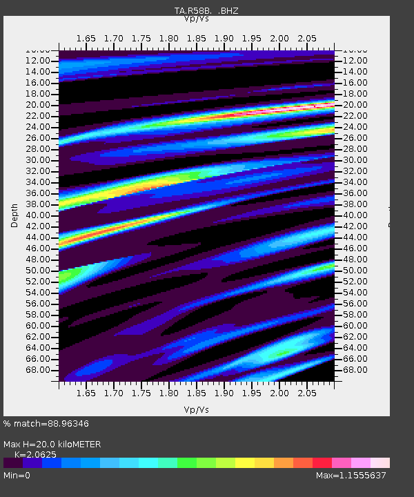
| Estimated Moho Depth: |
20.0 km |
| Estimated Crust Vp/Vs: |
2.06 |
| Assumed Crust Vp: |
6.565 km/s |
| Estimated Crust Vs: |
3.183 km/s |
| Estimated Crust Poisson's Ratio: |
0.35 |
|
| Radial Match: |
88.96346 % |
| Radial Bump: |
364 |
| Transverse Match: |
76.535 % |
| Transverse Bump: |
400 |
| SOD ConfigId: |
769524 |
| Insert Time: |
2014-08-10 02:41:50.335 +0000 |
| GWidth: |
2.5 |
| Max Bumps: |
400 |
| Tol: |
0.001 |
|

Signal To Noise
| Channel | StoN | STA | LTA |
| TA:R58B: :BHZ:20140727T01:34:24.074994Z | 4.99992 | 3.2512182E-7 | 6.5025404E-8 |
| TA:R58B: :BHN:20140727T01:34:24.074994Z | 1.7434336 | 9.290968E-8 | 5.3291206E-8 |
| TA:R58B: :BHE:20140727T01:34:24.074994Z | 3.989039 | 2.0495288E-7 | 5.1379015E-8 |
| Arrivals |
| Ps | 3.5 SECOND |
| PpPs | 8.7 SECOND |
| PsPs/PpSs | 12 SECOND |


