You are here: Home > Network List > TA - USArray Transportable Network (new EarthScope stations) Stations List
> Station S56A Natural Bridge, VA, USA > Earthquake Result Viewer
S56A Natural Bridge, VA, USA - Earthquake Result Viewer
| Earthquake location: |
Northern Mid-Atlantic Ridge |
| Earthquake latitude/longitude: |
23.8/-45.6 |
| Earthquake time(UTC): |
2014/07/27 (208) 01:28:38 GMT |
| Earthquake Depth: |
10 km |
| Earthquake Magnitude: |
5.6 MB, 6.0 MWB, 6.6 MI |
| Earthquake Catalog/Contributor: |
NEIC PDE/NEIC COMCAT |
|
| Network: |
TA USArray Transportable Network (new EarthScope stations) |
| Station: |
S56A Natural Bridge, VA, USA |
| Lat/Lon: |
37.68 N/79.57 W |
| Elevation: |
449 m |
|
| Distance: |
32.1 deg |
| Az: |
303.57 deg |
| Baz: |
105.817 deg |
| Ray Param: |
0.07879513 |
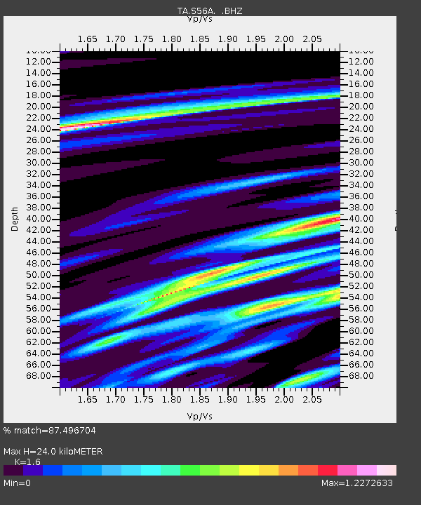
| Estimated Moho Depth: |
24.0 km |
| Estimated Crust Vp/Vs: |
1.60 |
| Assumed Crust Vp: |
6.419 km/s |
| Estimated Crust Vs: |
4.012 km/s |
| Estimated Crust Poisson's Ratio: |
0.18 |
|
| Radial Match: |
87.496704 % |
| Radial Bump: |
315 |
| Transverse Match: |
73.55989 % |
| Transverse Bump: |
400 |
| SOD ConfigId: |
769524 |
| Insert Time: |
2014-08-10 02:42:14.721 +0000 |
| GWidth: |
2.5 |
| Max Bumps: |
400 |
| Tol: |
0.001 |
|
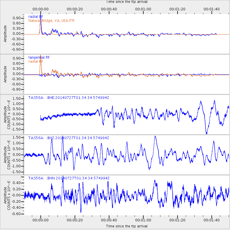
Signal To Noise
| Channel | StoN | STA | LTA |
| TA:S56A: :BHZ:20140727T01:34:34.574994Z | 4.320356 | 3.303801E-7 | 7.647057E-8 |
| TA:S56A: :BHN:20140727T01:34:34.574994Z | 0.8872148 | 6.456266E-8 | 7.277005E-8 |
| TA:S56A: :BHE:20140727T01:34:34.574994Z | 1.7546743 | 3.0372343E-7 | 1.7309391E-7 |
| Arrivals |
| Ps | 2.5 SECOND |
| PpPs | 8.9 SECOND |
| PsPs/PpSs | 11 SECOND |


