You are here: Home > Network List > XD14 - Illuminating the architecture of the greater Mount St. Helens magmatic systems f Stations List
> Station MN07 "Mount St Helens, WA" > Earthquake Result Viewer
MN07 "Mount St Helens, WA" - Earthquake Result Viewer
| Earthquake location: |
Tonga Islands |
| Earthquake latitude/longitude: |
-15.2/-173.2 |
| Earthquake time(UTC): |
2015/04/07 (097) 00:46:18 GMT |
| Earthquake Depth: |
10 km |
| Earthquake Magnitude: |
5.8 MB |
| Earthquake Catalog/Contributor: |
NEIC PDE/NEIC ALERT |
|
| Network: |
XD Illuminating the architecture of the greater Mount St. Helens magmatic systems f |
| Station: |
MN07 "Mount St Helens, WA" |
| Lat/Lon: |
45.99 N/122.08 W |
| Elevation: |
861 m |
|
| Distance: |
76.4 deg |
| Az: |
33.958 deg |
| Baz: |
230.675 deg |
| Ray Param: |
0.051035274 |
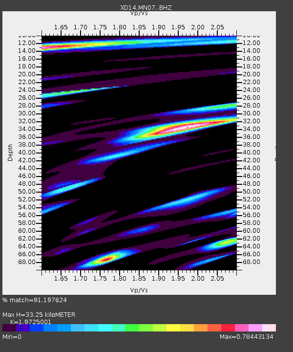
| Estimated Moho Depth: |
33.25 km |
| Estimated Crust Vp/Vs: |
1.97 |
| Assumed Crust Vp: |
6.566 km/s |
| Estimated Crust Vs: |
3.329 km/s |
| Estimated Crust Poisson's Ratio: |
0.33 |
|
| Radial Match: |
91.197624 % |
| Radial Bump: |
400 |
| Transverse Match: |
78.35147 % |
| Transverse Bump: |
400 |
| SOD ConfigId: |
7422571 |
| Insert Time: |
2019-04-18 03:05:41.872 +0000 |
| GWidth: |
2.5 |
| Max Bumps: |
400 |
| Tol: |
0.001 |
|

Signal To Noise
| Channel | StoN | STA | LTA |
| XD:MN07: :BHZ:20150407T00:57:37.269971Z | 33.110695 | 4.7594626E-6 | 1.4374396E-7 |
| XD:MN07: :BHN:20150407T00:57:37.269971Z | 4.5302453 | 9.521774E-7 | 2.101823E-7 |
| XD:MN07: :BHE:20150407T00:57:37.269971Z | 8.605739 | 1.6478848E-6 | 1.9148673E-7 |
| Arrivals |
| Ps | 5.1 SECOND |
| PpPs | 15 SECOND |
| PsPs/PpSs | 20 SECOND |


