You are here: Home > Network List > XD14 - Illuminating the architecture of the greater Mount St. Helens magmatic systems f Stations List
> Station MO07 "Mount St Helens, WA" > Earthquake Result Viewer
MO07 "Mount St Helens, WA" - Earthquake Result Viewer
| Earthquake location: |
Tonga Islands |
| Earthquake latitude/longitude: |
-15.2/-173.2 |
| Earthquake time(UTC): |
2015/04/07 (097) 00:46:18 GMT |
| Earthquake Depth: |
10 km |
| Earthquake Magnitude: |
5.8 MB |
| Earthquake Catalog/Contributor: |
NEIC PDE/NEIC ALERT |
|
| Network: |
XD Illuminating the architecture of the greater Mount St. Helens magmatic systems f |
| Station: |
MO07 "Mount St Helens, WA" |
| Lat/Lon: |
45.89 N/122.08 W |
| Elevation: |
1248 m |
|
| Distance: |
76.3 deg |
| Az: |
34.042 deg |
| Baz: |
230.693 deg |
| Ray Param: |
0.05108204 |
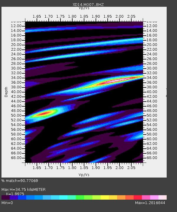
| Estimated Moho Depth: |
34.75 km |
| Estimated Crust Vp/Vs: |
2.00 |
| Assumed Crust Vp: |
6.566 km/s |
| Estimated Crust Vs: |
3.287 km/s |
| Estimated Crust Poisson's Ratio: |
0.33 |
|
| Radial Match: |
90.77069 % |
| Radial Bump: |
400 |
| Transverse Match: |
85.46905 % |
| Transverse Bump: |
400 |
| SOD ConfigId: |
7422571 |
| Insert Time: |
2019-04-18 03:05:44.194 +0000 |
| GWidth: |
2.5 |
| Max Bumps: |
400 |
| Tol: |
0.001 |
|

Signal To Noise
| Channel | StoN | STA | LTA |
| XD:MO07: :BHZ:20150407T00:57:36.890027Z | 25.56865 | 4.2310135E-6 | 1.6547662E-7 |
| XD:MO07: :BHN:20150407T00:57:36.890027Z | 10.163699 | 1.3744586E-6 | 1.3523213E-7 |
| XD:MO07: :BHE:20150407T00:57:36.890027Z | 6.374191 | 1.7012109E-6 | 2.6689048E-7 |
| Arrivals |
| Ps | 5.4 SECOND |
| PpPs | 15 SECOND |
| PsPs/PpSs | 21 SECOND |


