You are here: Home > Network List > TA - USArray Transportable Network (new EarthScope stations) Stations List
> Station U58A Oxford, NC, USA > Earthquake Result Viewer
U58A Oxford, NC, USA - Earthquake Result Viewer
| Earthquake location: |
Northern Mid-Atlantic Ridge |
| Earthquake latitude/longitude: |
23.8/-45.6 |
| Earthquake time(UTC): |
2014/07/27 (208) 01:28:38 GMT |
| Earthquake Depth: |
10 km |
| Earthquake Magnitude: |
5.6 MB, 6.0 MWB, 6.6 MI |
| Earthquake Catalog/Contributor: |
NEIC PDE/NEIC COMCAT |
|
| Network: |
TA USArray Transportable Network (new EarthScope stations) |
| Station: |
U58A Oxford, NC, USA |
| Lat/Lon: |
36.39 N/78.55 W |
| Elevation: |
169 m |
|
| Distance: |
31.0 deg |
| Az: |
301.62 deg |
| Baz: |
104.764 deg |
| Ray Param: |
0.07919017 |
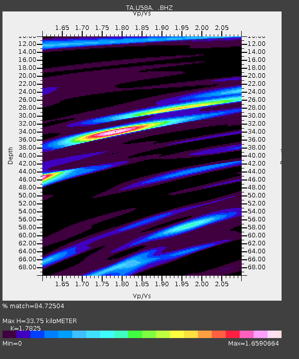
| Estimated Moho Depth: |
33.75 km |
| Estimated Crust Vp/Vs: |
1.78 |
| Assumed Crust Vp: |
6.419 km/s |
| Estimated Crust Vs: |
3.601 km/s |
| Estimated Crust Poisson's Ratio: |
0.27 |
|
| Radial Match: |
84.72504 % |
| Radial Bump: |
308 |
| Transverse Match: |
63.959015 % |
| Transverse Bump: |
400 |
| SOD ConfigId: |
769524 |
| Insert Time: |
2014-08-10 02:43:56.412 +0000 |
| GWidth: |
2.5 |
| Max Bumps: |
400 |
| Tol: |
0.001 |
|
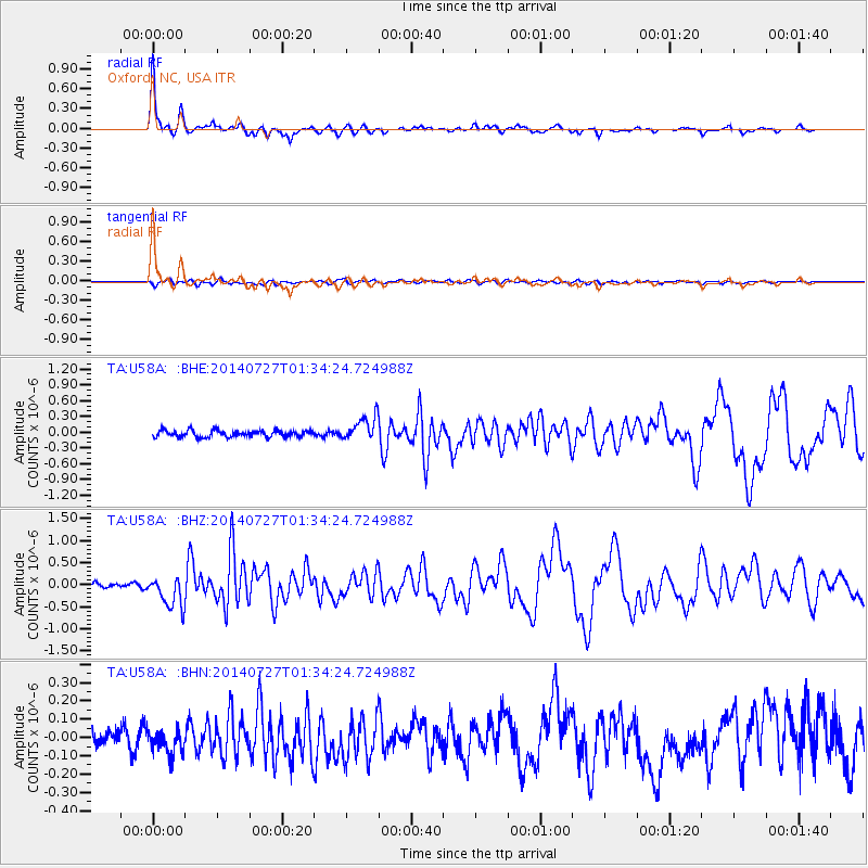
Signal To Noise
| Channel | StoN | STA | LTA |
| TA:U58A: :BHZ:20140727T01:34:24.724988Z | 6.0775895 | 3.5885375E-7 | 5.9045405E-8 |
| TA:U58A: :BHN:20140727T01:34:24.724988Z | 1.1174262 | 6.908354E-8 | 6.182381E-8 |
| TA:U58A: :BHE:20140727T01:34:24.724988Z | 3.7210288 | 2.3248438E-7 | 6.247852E-8 |
| Arrivals |
| Ps | 4.5 SECOND |
| PpPs | 14 SECOND |
| PsPs/PpSs | 18 SECOND |


