You are here: Home > Network List > TA - USArray Transportable Network (new EarthScope stations) Stations List
> Station W57A Gilead, NC, USA > Earthquake Result Viewer
W57A Gilead, NC, USA - Earthquake Result Viewer
| Earthquake location: |
Northern Mid-Atlantic Ridge |
| Earthquake latitude/longitude: |
23.8/-45.6 |
| Earthquake time(UTC): |
2014/07/27 (208) 01:28:38 GMT |
| Earthquake Depth: |
10 km |
| Earthquake Magnitude: |
5.6 MB, 6.0 MWB, 6.6 MI |
| Earthquake Catalog/Contributor: |
NEIC PDE/NEIC COMCAT |
|
| Network: |
TA USArray Transportable Network (new EarthScope stations) |
| Station: |
W57A Gilead, NC, USA |
| Lat/Lon: |
35.15 N/79.99 W |
| Elevation: |
85 m |
|
| Distance: |
31.8 deg |
| Az: |
298.793 deg |
| Baz: |
101.511 deg |
| Ray Param: |
0.07890608 |
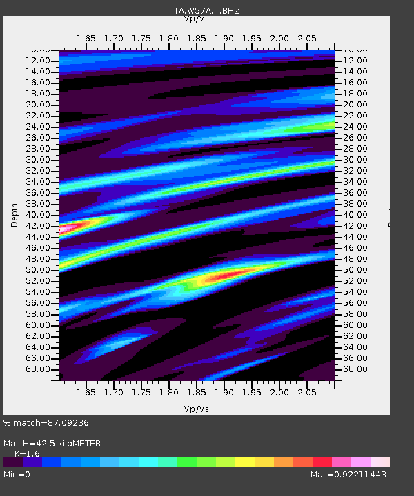
| Estimated Moho Depth: |
42.5 km |
| Estimated Crust Vp/Vs: |
1.60 |
| Assumed Crust Vp: |
6.565 km/s |
| Estimated Crust Vs: |
4.103 km/s |
| Estimated Crust Poisson's Ratio: |
0.18 |
|
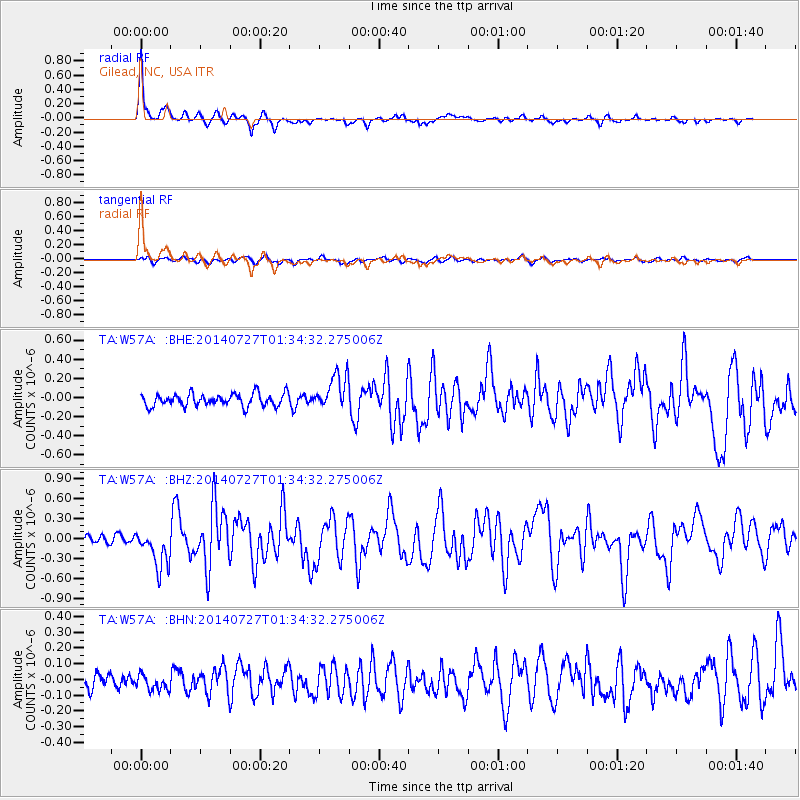
| Radial Match: |
87.09236 % |
| Radial Bump: |
291 |
| Transverse Match: |
60.84271 % |
| Transverse Bump: |
382 |
| SOD ConfigId: |
769524 |
| Insert Time: |
2014-08-10 02:44:51.795 +0000 |
| GWidth: |
2.5 |
| Max Bumps: |
400 |
| Tol: |
0.001 |
|
Signal To Noise
| Channel | StoN | STA | LTA |
| TA:W57A: :BHZ:20140727T01:34:32.275006Z | 4.0930133 | 2.9363895E-7 | 7.17415E-8 |
| TA:W57A: :BHN:20140727T01:34:32.275006Z | 1.0267283 | 5.090559E-8 | 4.958039E-8 |
| TA:W57A: :BHE:20140727T01:34:32.275006Z | 2.909165 | 1.8761176E-7 | 6.44899E-8 |
| Arrivals |
| Ps | 4.3 SECOND |
| PpPs | 15 SECOND |
| PsPs/PpSs | 20 SECOND |


