You are here: Home > Network List > TA - USArray Transportable Network (new EarthScope stations) Stations List
> Station W58A Raeford, NC, USA > Earthquake Result Viewer
W58A Raeford, NC, USA - Earthquake Result Viewer
| Earthquake location: |
Northern Mid-Atlantic Ridge |
| Earthquake latitude/longitude: |
23.8/-45.6 |
| Earthquake time(UTC): |
2014/07/27 (208) 01:28:38 GMT |
| Earthquake Depth: |
10 km |
| Earthquake Magnitude: |
5.6 MB, 6.0 MWB, 6.6 MI |
| Earthquake Catalog/Contributor: |
NEIC PDE/NEIC COMCAT |
|
| Network: |
TA USArray Transportable Network (new EarthScope stations) |
| Station: |
W58A Raeford, NC, USA |
| Lat/Lon: |
35.02 N/79.23 W |
| Elevation: |
84 m |
|
| Distance: |
31.2 deg |
| Az: |
298.788 deg |
| Baz: |
101.942 deg |
| Ray Param: |
0.07913102 |
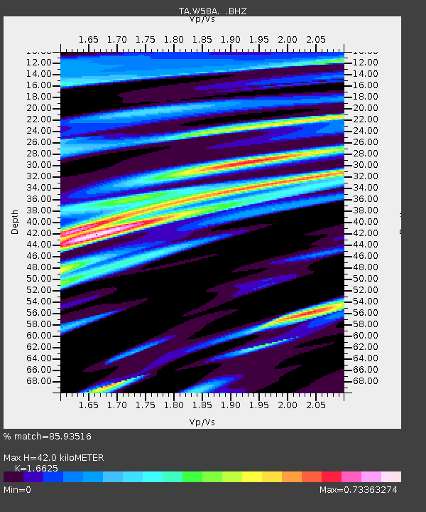
| Estimated Moho Depth: |
42.0 km |
| Estimated Crust Vp/Vs: |
1.66 |
| Assumed Crust Vp: |
6.565 km/s |
| Estimated Crust Vs: |
3.949 km/s |
| Estimated Crust Poisson's Ratio: |
0.22 |
|
| Radial Match: |
85.93516 % |
| Radial Bump: |
400 |
| Transverse Match: |
55.470222 % |
| Transverse Bump: |
400 |
| SOD ConfigId: |
769524 |
| Insert Time: |
2014-08-10 02:44:55.492 +0000 |
| GWidth: |
2.5 |
| Max Bumps: |
400 |
| Tol: |
0.001 |
|
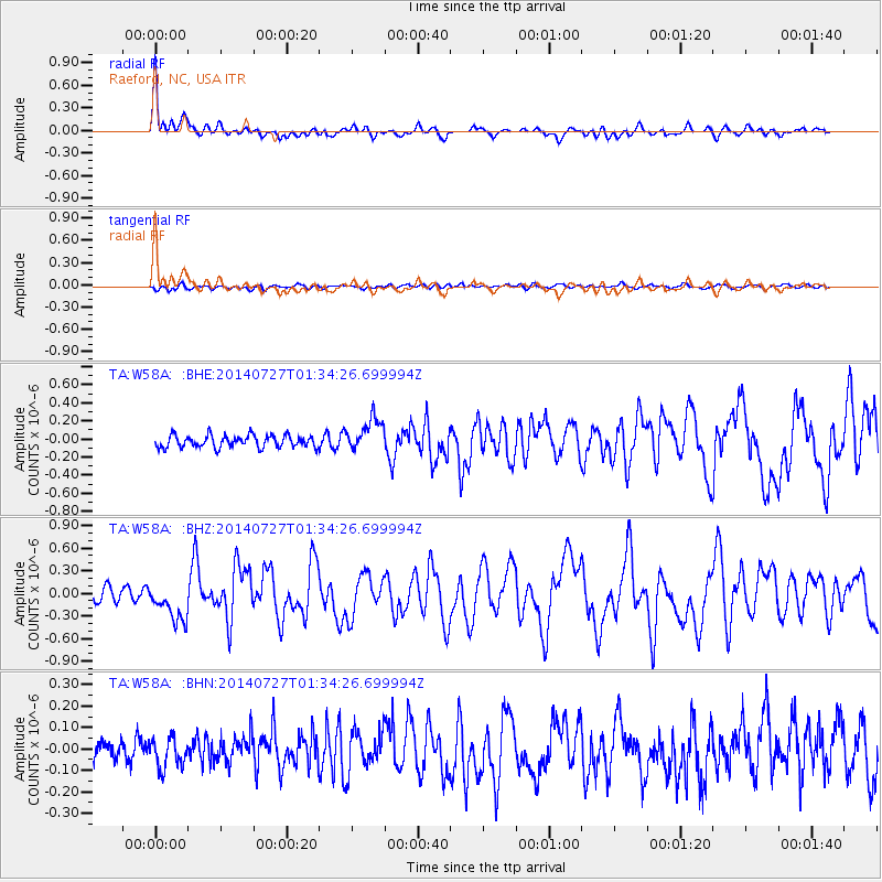
Signal To Noise
| Channel | StoN | STA | LTA |
| TA:W58A: :BHZ:20140727T01:34:26.699994Z | 3.332788 | 2.5250083E-7 | 7.576264E-8 |
| TA:W58A: :BHN:20140727T01:34:26.699994Z | 1.2997059 | 6.62741E-8 | 5.0991613E-8 |
| TA:W58A: :BHE:20140727T01:34:26.699994Z | 2.6978931 | 1.8241094E-7 | 6.761237E-8 |
| Arrivals |
| Ps | 4.6 SECOND |
| PpPs | 16 SECOND |
| PsPs/PpSs | 20 SECOND |


