You are here: Home > Network List > TA - USArray Transportable Network (new EarthScope stations) Stations List
> Station X55A Gracelyn & Ava, Whitmire, SC, USA > Earthquake Result Viewer
X55A Gracelyn & Ava, Whitmire, SC, USA - Earthquake Result Viewer
| Earthquake location: |
Northern Mid-Atlantic Ridge |
| Earthquake latitude/longitude: |
23.8/-45.6 |
| Earthquake time(UTC): |
2014/07/27 (208) 01:28:38 GMT |
| Earthquake Depth: |
10 km |
| Earthquake Magnitude: |
5.6 MB, 6.0 MWB, 6.6 MI |
| Earthquake Catalog/Contributor: |
NEIC PDE/NEIC COMCAT |
|
| Network: |
TA USArray Transportable Network (new EarthScope stations) |
| Station: |
X55A Gracelyn & Ava, Whitmire, SC, USA |
| Lat/Lon: |
34.47 N/81.63 W |
| Elevation: |
153 m |
|
| Distance: |
33.0 deg |
| Az: |
297.092 deg |
| Baz: |
99.143 deg |
| Ray Param: |
0.07838883 |
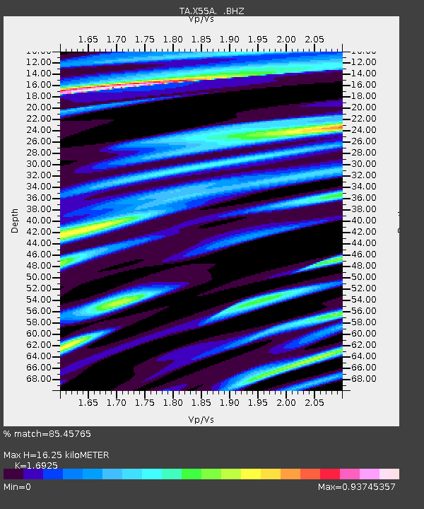
| Estimated Moho Depth: |
16.25 km |
| Estimated Crust Vp/Vs: |
1.69 |
| Assumed Crust Vp: |
6.419 km/s |
| Estimated Crust Vs: |
3.793 km/s |
| Estimated Crust Poisson's Ratio: |
0.23 |
|
| Radial Match: |
85.45765 % |
| Radial Bump: |
400 |
| Transverse Match: |
70.517746 % |
| Transverse Bump: |
400 |
| SOD ConfigId: |
769524 |
| Insert Time: |
2014-08-10 02:45:20.929 +0000 |
| GWidth: |
2.5 |
| Max Bumps: |
400 |
| Tol: |
0.001 |
|

Signal To Noise
| Channel | StoN | STA | LTA |
| TA:X55A: :BHZ:20140727T01:34:42.824994Z | 4.7511053 | 2.5416207E-7 | 5.3495356E-8 |
| TA:X55A: :BHN:20140727T01:34:42.824994Z | 0.96386456 | 5.7222046E-8 | 5.9367313E-8 |
| TA:X55A: :BHE:20140727T01:34:42.824994Z | 3.2229803 | 1.7933883E-7 | 5.564379E-8 |
| Arrivals |
| Ps | 1.9 SECOND |
| PpPs | 6.3 SECOND |
| PsPs/PpSs | 8.2 SECOND |


