You are here: Home > Network List > TA - USArray Transportable Network (new EarthScope stations) Stations List
> Station Z41A Richland Creek Farm, El Dorado, AR, USA > Earthquake Result Viewer
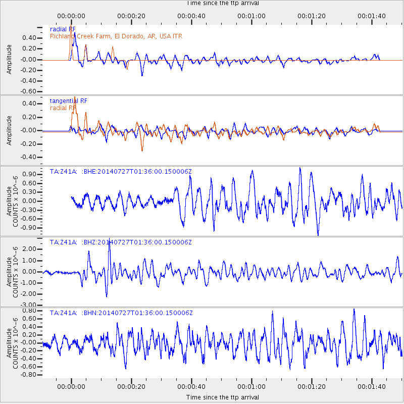
Z41A Richland Creek Farm, El Dorado, AR, USA - Earthquake Result Viewer
*The percent match for this event was below the threshold and hence no stack was calculated.
| Earthquake location: |
Northern Mid-Atlantic Ridge |
| Earthquake latitude/longitude: |
23.8/-45.6 |
| Earthquake time(UTC): |
2014/07/27 (208) 01:28:38 GMT |
| Earthquake Depth: |
10 km |
| Earthquake Magnitude: |
5.6 MB, 6.0 MWB, 6.6 MI |
| Earthquake Catalog/Contributor: |
NEIC PDE/NEIC COMCAT |
|
| Network: |
TA USArray Transportable Network (new EarthScope stations) |
| Station: |
Z41A Richland Creek Farm, El Dorado, AR, USA |
| Lat/Lon: |
33.26 N/92.80 W |
| Elevation: |
62 m |
|
| Distance: |
42.2 deg |
| Az: |
293.867 deg |
| Baz: |
90.371 deg |
| Ray Param: |
$rayparam |
*The percent match for this event was below the threshold and hence was not used in the summary stack. |
|
| Radial Match: |
83.22591 % |
| Radial Bump: |
347 |
| Transverse Match: |
60.387524 % |
| Transverse Bump: |
370 |
| SOD ConfigId: |
769524 |
| Insert Time: |
2014-08-10 02:45:59.826 +0000 |
| GWidth: |
2.5 |
| Max Bumps: |
400 |
| Tol: |
0.001 |
|
Signal To Noise
| Channel | StoN | STA | LTA |
| TA:Z41A: :BHZ:20140727T01:36:00.150006Z | 4.955618 | 3.7156497E-7 | 7.497854E-8 |
| TA:Z41A: :BHN:20140727T01:36:00.150006Z | 0.9314099 | 1.1427108E-7 | 1.2268613E-7 |
| TA:Z41A: :BHE:20140727T01:36:00.150006Z | 0.8567227 | 1.4661484E-7 | 1.7113453E-7 |
| Arrivals |
| Ps | |
| PpPs | |
| PsPs/PpSs | |


