You are here: Home > Network List > TA - USArray Transportable Network (new EarthScope stations) Stations List
> Station Z56A Williston, SC, USA > Earthquake Result Viewer
Z56A Williston, SC, USA - Earthquake Result Viewer
| Earthquake location: |
Northern Mid-Atlantic Ridge |
| Earthquake latitude/longitude: |
23.8/-45.6 |
| Earthquake time(UTC): |
2014/07/27 (208) 01:28:38 GMT |
| Earthquake Depth: |
10 km |
| Earthquake Magnitude: |
5.6 MB, 6.0 MWB, 6.6 MI |
| Earthquake Catalog/Contributor: |
NEIC PDE/NEIC COMCAT |
|
| Network: |
TA USArray Transportable Network (new EarthScope stations) |
| Station: |
Z56A Williston, SC, USA |
| Lat/Lon: |
33.33 N/81.37 W |
| Elevation: |
81 m |
|
| Distance: |
32.7 deg |
| Az: |
295.069 deg |
| Baz: |
97.591 deg |
| Ray Param: |
0.07855651 |
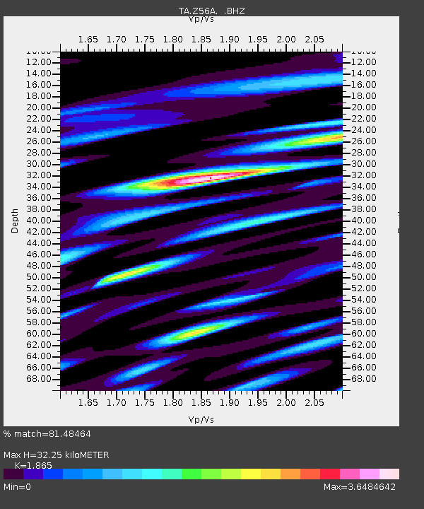
| Estimated Moho Depth: |
32.25 km |
| Estimated Crust Vp/Vs: |
1.87 |
| Assumed Crust Vp: |
6.565 km/s |
| Estimated Crust Vs: |
3.52 km/s |
| Estimated Crust Poisson's Ratio: |
0.30 |
|
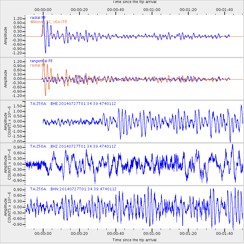
| Radial Match: |
81.48464 % |
| Radial Bump: |
400 |
| Transverse Match: |
56.842316 % |
| Transverse Bump: |
400 |
| SOD ConfigId: |
769524 |
| Insert Time: |
2014-08-10 02:46:02.145 +0000 |
| GWidth: |
2.5 |
| Max Bumps: |
400 |
| Tol: |
0.001 |
|
Signal To Noise
| Channel | StoN | STA | LTA |
| TA:Z56A: :BHZ:20140727T01:34:39.474011Z | 2.711673 | 2.4735397E-7 | 9.121821E-8 |
| TA:Z56A: :BHN:20140727T01:34:39.474011Z | 0.73092955 | 1.3990267E-7 | 1.9140376E-7 |
| TA:Z56A: :BHE:20140727T01:34:39.474011Z | 2.007538 | 3.1319152E-7 | 1.5600777E-7 |
| Arrivals |
| Ps | 4.6 SECOND |
| PpPs | 13 SECOND |
| PsPs/PpSs | 18 SECOND |


