You are here: Home > Network List > YT07 - POLENET Stations List
> Station FISH FISH > Earthquake Result Viewer
FISH FISH - Earthquake Result Viewer
| Earthquake location: |
Tonga Islands |
| Earthquake latitude/longitude: |
-15.2/-173.2 |
| Earthquake time(UTC): |
2015/04/07 (097) 00:46:18 GMT |
| Earthquake Depth: |
10 km |
| Earthquake Magnitude: |
5.8 MB |
| Earthquake Catalog/Contributor: |
NEIC PDE/NEIC ALERT |
|
| Network: |
YT POLENET |
| Station: |
FISH FISH |
| Lat/Lon: |
78.93 S/162.57 E |
| Elevation: |
273 m |
|
| Distance: |
64.8 deg |
| Az: |
185.026 deg |
| Baz: |
25.952 deg |
| Ray Param: |
0.058691427 |
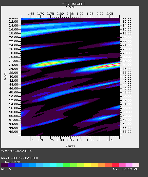
| Estimated Moho Depth: |
33.75 km |
| Estimated Crust Vp/Vs: |
2.07 |
| Assumed Crust Vp: |
6.43 km/s |
| Estimated Crust Vs: |
3.11 km/s |
| Estimated Crust Poisson's Ratio: |
0.35 |
|
| Radial Match: |
92.23774 % |
| Radial Bump: |
400 |
| Transverse Match: |
85.59743 % |
| Transverse Bump: |
400 |
| SOD ConfigId: |
7422571 |
| Insert Time: |
2019-04-18 03:06:38.264 +0000 |
| GWidth: |
2.5 |
| Max Bumps: |
400 |
| Tol: |
0.001 |
|

Signal To Noise
| Channel | StoN | STA | LTA |
| YT:FISH: :BHZ:20150407T00:56:24.974011Z | 27.346813 | 3.3994002E-6 | 1.24307E-7 |
| YT:FISH: :BHN:20150407T00:56:24.974011Z | 11.472116 | 1.0830728E-6 | 9.4409145E-8 |
| YT:FISH: :BHE:20150407T00:56:24.974011Z | 6.1294765 | 8.4865115E-7 | 1.384541E-7 |
| Arrivals |
| Ps | 5.8 SECOND |
| PpPs | 16 SECOND |
| PsPs/PpSs | 21 SECOND |


