You are here: Home > Network List > US - United States National Seismic Network Stations List
> Station MNTX Cornudas Mountains, Texas, USA > Earthquake Result Viewer
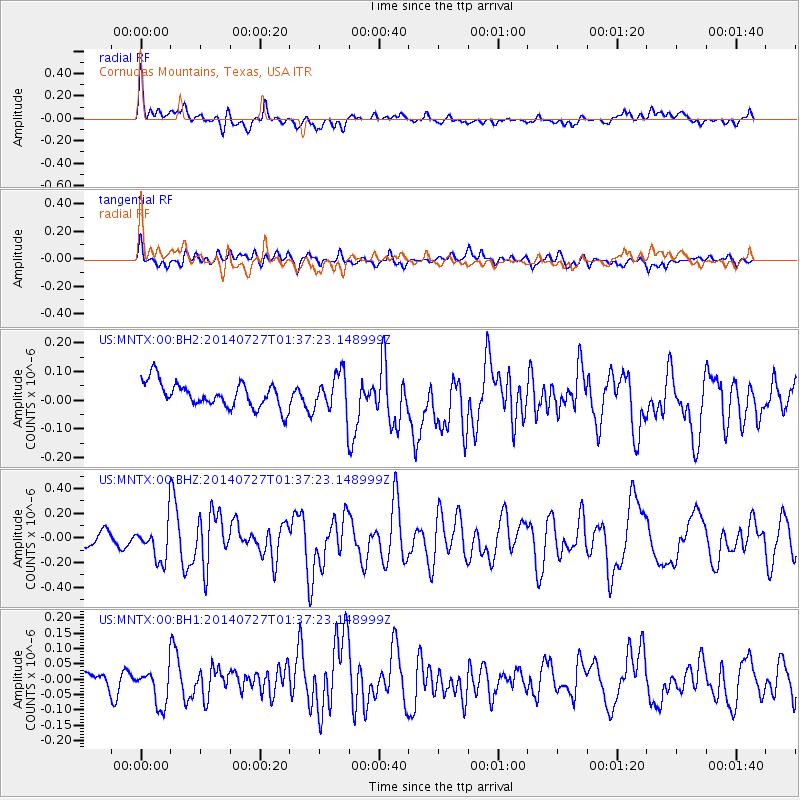
MNTX Cornudas Mountains, Texas, USA - Earthquake Result Viewer
*The percent match for this event was below the threshold and hence no stack was calculated.
| Earthquake location: |
Northern Mid-Atlantic Ridge |
| Earthquake latitude/longitude: |
23.8/-45.6 |
| Earthquake time(UTC): |
2014/07/27 (208) 01:28:38 GMT |
| Earthquake Depth: |
10 km |
| Earthquake Magnitude: |
5.6 MB, 6.0 MWB, 6.6 MI |
| Earthquake Catalog/Contributor: |
NEIC PDE/NEIC COMCAT |
|
| Network: |
US United States National Seismic Network |
| Station: |
MNTX Cornudas Mountains, Texas, USA |
| Lat/Lon: |
31.70 N/105.38 W |
| Elevation: |
404 m |
|
| Distance: |
52.9 deg |
| Az: |
292.634 deg |
| Baz: |
82.793 deg |
| Ray Param: |
$rayparam |
*The percent match for this event was below the threshold and hence was not used in the summary stack. |
|
| Radial Match: |
72.74437 % |
| Radial Bump: |
400 |
| Transverse Match: |
57.81821 % |
| Transverse Bump: |
400 |
| SOD ConfigId: |
769524 |
| Insert Time: |
2014-08-10 02:49:22.958 +0000 |
| GWidth: |
2.5 |
| Max Bumps: |
400 |
| Tol: |
0.001 |
|
Signal To Noise
| Channel | StoN | STA | LTA |
| US:MNTX:00:BHZ:20140727T01:37:23.148999Z | 3.0395477 | 1.5196049E-7 | 4.9994444E-8 |
| US:MNTX:00:BH1:20140727T01:37:23.148999Z | 1.3240613 | 6.387317E-8 | 4.8240345E-8 |
| US:MNTX:00:BH2:20140727T01:37:23.148999Z | 1.5180765 | 6.6735126E-8 | 4.3960316E-8 |
| Arrivals |
| Ps | |
| PpPs | |
| PsPs/PpSs | |


