You are here: Home > Network List > US - United States National Seismic Network Stations List
> Station MSO Missoula, Montana, USA > Earthquake Result Viewer
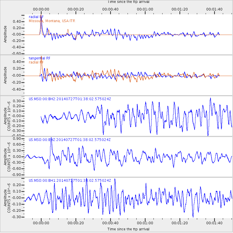
MSO Missoula, Montana, USA - Earthquake Result Viewer
*The percent match for this event was below the threshold and hence no stack was calculated.
| Earthquake location: |
Northern Mid-Atlantic Ridge |
| Earthquake latitude/longitude: |
23.8/-45.6 |
| Earthquake time(UTC): |
2014/07/27 (208) 01:28:38 GMT |
| Earthquake Depth: |
10 km |
| Earthquake Magnitude: |
5.6 MB, 6.0 MWB, 6.6 MI |
| Earthquake Catalog/Contributor: |
NEIC PDE/NEIC COMCAT |
|
| Network: |
US United States National Seismic Network |
| Station: |
MSO Missoula, Montana, USA |
| Lat/Lon: |
46.83 N/113.94 W |
| Elevation: |
1264 m |
|
| Distance: |
58.4 deg |
| Az: |
311.499 deg |
| Baz: |
88.066 deg |
| Ray Param: |
$rayparam |
*The percent match for this event was below the threshold and hence was not used in the summary stack. |
|
| Radial Match: |
77.66999 % |
| Radial Bump: |
400 |
| Transverse Match: |
67.80355 % |
| Transverse Bump: |
400 |
| SOD ConfigId: |
769524 |
| Insert Time: |
2014-08-10 02:49:23.300 +0000 |
| GWidth: |
2.5 |
| Max Bumps: |
400 |
| Tol: |
0.001 |
|
Signal To Noise
| Channel | StoN | STA | LTA |
| US:MSO:00:BHZ:20140727T01:38:02.575024Z | 4.51226 | 2.3250969E-7 | 5.1528435E-8 |
| US:MSO:00:BH1:20140727T01:38:02.575024Z | 1.8239964 | 6.7026164E-8 | 3.6746872E-8 |
| US:MSO:00:BH2:20140727T01:38:02.575024Z | 2.07448 | 1.1520646E-7 | 5.5535104E-8 |
| Arrivals |
| Ps | |
| PpPs | |
| PsPs/PpSs | |


