You are here: Home > Network List > WY - Yellowstone Wyoming Seismic Network Stations List
> Station YHB Horse Butte YNP, MT, USA > Earthquake Result Viewer
YHB Horse Butte YNP, MT, USA - Earthquake Result Viewer
| Earthquake location: |
Northern Mid-Atlantic Ridge |
| Earthquake latitude/longitude: |
23.8/-45.6 |
| Earthquake time(UTC): |
2014/07/27 (208) 01:28:38 GMT |
| Earthquake Depth: |
10 km |
| Earthquake Magnitude: |
5.6 MB, 6.0 MWB, 6.6 MI |
| Earthquake Catalog/Contributor: |
NEIC PDE/NEIC COMCAT |
|
| Network: |
WY Yellowstone Wyoming Seismic Network |
| Station: |
YHB Horse Butte YNP, MT, USA |
| Lat/Lon: |
44.75 N/111.20 W |
| Elevation: |
2167 m |
|
| Distance: |
56.5 deg |
| Az: |
308.97 deg |
| Baz: |
88.667 deg |
| Ray Param: |
0.0640743 |
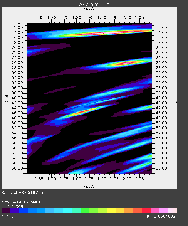
| Estimated Moho Depth: |
14.0 km |
| Estimated Crust Vp/Vs: |
1.90 |
| Assumed Crust Vp: |
6.35 km/s |
| Estimated Crust Vs: |
3.333 km/s |
| Estimated Crust Poisson's Ratio: |
0.31 |
|
| Radial Match: |
87.519775 % |
| Radial Bump: |
400 |
| Transverse Match: |
84.15546 % |
| Transverse Bump: |
400 |
| SOD ConfigId: |
769524 |
| Insert Time: |
2014-08-10 02:56:04.029 +0000 |
| GWidth: |
2.5 |
| Max Bumps: |
400 |
| Tol: |
0.001 |
|

Signal To Noise
| Channel | StoN | STA | LTA |
| WY:YHB:01:HHZ:20140727T01:37:49.469983Z | 3.4359953 | 7.0082042E-9 | 2.0396431E-9 |
| WY:YHB:01:HHN:20140727T01:37:49.469983Z | 0.71371317 | 1.6076466E-9 | 2.2525108E-9 |
| WY:YHB:01:HHE:20140727T01:37:49.469983Z | 2.8270893 | 3.9290957E-9 | 1.3898025E-9 |
| Arrivals |
| Ps | 2.1 SECOND |
| PpPs | 6.1 SECOND |
| PsPs/PpSs | 8.2 SECOND |


